

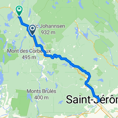
labelle - lac chaud
A cycling route starting in Labelle, Quebec, Canada.
Overview
About this route
- -:--
- Duration
- 56.7 km
- Distance
- 283 m
- Ascent
- 281 m
- Descent
- ---
- Avg. speed
- 281 m
- Max. altitude

Route quality
Waytypes & surfaces along the route
Waytypes
Road
43.7 km
(77 %)
Quiet road
13 km
(23 %)
Surfaces
Paved
41.4 km
(73 %)
Unpaved
15.3 km
(27 %)
Asphalt
41.4 km
(73 %)
Unpaved (undefined)
15.3 km
(27 %)
Continue with Bikemap
Use, edit, or download this cycling route
You would like to ride labelle - lac chaud or customize it for your own trip? Here is what you can do with this Bikemap route:
Free features
- Save this route as favorite or in collections
- Copy & plan your own version of this route
- Sync your route with Garmin or Wahoo
Premium features
Free trial for 3 days, or one-time payment. More about Bikemap Premium.
- Navigate this route on iOS & Android
- Export a GPX / KML file of this route
- Create your custom printout (try it for free)
- Download this route for offline navigation
Discover more Premium features.
Get Bikemap PremiumFrom our community
Other popular routes starting in Labelle
 Tremblant Le P’tit Train Labelle to Lac Nominingue
- Distance
- 71 km
- Ascent
- 112 m
- Descent
- 112 m
- Location
- Labelle, Quebec, Canada
 August 28 Biking
- Distance
- 4,816.8 km
- Ascent
- 33,972 m
- Descent
- 34,198 m
- Location
- Labelle, Quebec, Canada
 P'tit Train du Nord, Labelle to Rue Labelle 1296, Mont-Tremblant
- Distance
- 23.1 km
- Ascent
- 147 m
- Descent
- 141 m
- Location
- Labelle, Quebec, Canada
 Ch du Lac-Caché, Labelle à 7601–7687 Boul du Curé-Labelle N, Labelle
- Distance
- 75.6 km
- Ascent
- 675 m
- Descent
- 682 m
- Location
- Labelle, Quebec, Canada
 le petit train du nord
- Distance
- 238.9 km
- Ascent
- 1,265 m
- Descent
- 1,247 m
- Location
- Labelle, Quebec, Canada
 20250929_4 La Macaza - Marchand
- Distance
- 17.5 km
- Ascent
- 140 m
- Descent
- 73 m
- Location
- Labelle, Quebec, Canada
 Labelle à Mont-Laurier, La Macaza to Labelle à Mont-Laurier, La Macaza
- Distance
- 0.5 km
- Ascent
- 0 m
- Descent
- 0 m
- Location
- Labelle, Quebec, Canada
 Recovered Route
- Distance
- 17.4 km
- Ascent
- 455 m
- Descent
- 472 m
- Location
- Labelle, Quebec, Canada
Open it in the app