

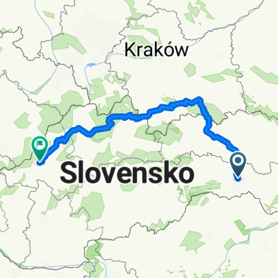
Tour de Davidov
A cycling route starting in Košice, Košice Region, Slovakia.
Overview
About this route
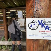
this road is awesome This road is quite simple for cycling and it has got amazing nature around The end of the road is cart-way so you have to use mountain bike :)
- -:--
- Duration
- 41 km
- Distance
- 740 m
- Ascent
- 832 m
- Descent
- ---
- Avg. speed
- ---
- Max. altitude
Route quality
Waytypes & surfaces along the route
Waytypes
Track
5.3 km
(13 %)
Quiet road
2.9 km
(7 %)
Surfaces
Paved
25 km
(61 %)
Unpaved
5.3 km
(13 %)
Asphalt
25 km
(61 %)
Ground
4.5 km
(11 %)
Route highlights
Points of interest along the route

Point of interest after 6.1 km
sprint Kosicke olsany

Point of interest after 16 km
sprint Bidovce

Point of interest after 28.7 km
herľany (670m)
Continue with Bikemap
Use, edit, or download this cycling route
You would like to ride Tour de Davidov or customize it for your own trip? Here is what you can do with this Bikemap route:
Free features
- Save this route as favorite or in collections
- Copy & plan your own version of this route
- Sync your route with Garmin or Wahoo
Premium features
Free trial for 3 days, or one-time payment. More about Bikemap Premium.
- Navigate this route on iOS & Android
- Export a GPX / KML file of this route
- Create your custom printout (try it for free)
- Download this route for offline navigation
Discover more Premium features.
Get Bikemap PremiumFrom our community
Other popular routes starting in Košice
 Jahodna-Lajoska a naspät
- Distance
- 39.6 km
- Ascent
- 1,265 m
- Descent
- 1,256 m
- Location
- Košice, Košice Region, Slovakia
 Vyšna Myšľa-Izra
- Distance
- 19 km
- Ascent
- 519 m
- Descent
- 323 m
- Location
- Košice, Košice Region, Slovakia
 ke-rudnik--medzev-stos-uhorna
- Distance
- 63.2 km
- Ascent
- 1,276 m
- Descent
- 778 m
- Location
- Košice, Košice Region, Slovakia
 Košice - Bankov - Jahodná
- Distance
- 14 km
- Ascent
- 497 m
- Descent
- 117 m
- Location
- Košice, Košice Region, Slovakia
 Tour de Davidov
- Distance
- 41 km
- Ascent
- 740 m
- Descent
- 832 m
- Location
- Košice, Košice Region, Slovakia
 Route slovaque
- Distance
- 454 km
- Ascent
- 5,362 m
- Descent
- 5,355 m
- Location
- Košice, Košice Region, Slovakia
 Lajoška 26.6.2010
- Distance
- 43 km
- Ascent
- 851 m
- Descent
- 853 m
- Location
- Košice, Košice Region, Slovakia
 V.Myšľa -Karolka-Vlašske luky-V.Milič
- Distance
- 29.7 km
- Ascent
- 882 m
- Descent
- 883 m
- Location
- Košice, Košice Region, Slovakia
Open it in the app