

Drei-Schlösser-Runde
A cycling route starting in Schwandorf in Bayern, Bavaria, Germany.
Overview
About this route
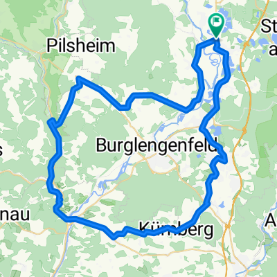
The route starts and ends in Schwandorf at the junction of Krondorfer Strasse and Nürnberger Strasse. In close proximity, on the festival square at Angerring, there is free parking available, except during the folk festival in the week after Ascension.
The route proceeds clockwise over Schwarzenfeld, Nabburg, Perschen, and Neusath to Guteneck, through the Schwarzachtal valley up to Altfalter, continuing over Richt, Weiding, and Hohenirlach, passing the Murnersee via Rauberweiherhaus and the airfield to Wackersdorf and back to Schwandorf. Along the route are the castles of Schwarzenfeld, Neusath, and Guteneck. Without visits and stops, the route can easily be done as a half-day tour. The route can also be traveled counterclockwise. In this case, Friedrich-Ebert-Straße cannot be accessed (one-way street!). Detour via Naabuferstraße (turn right at the traffic light at the end of the Naab bridges), Ettmannsdorfer Straße, Güterhallenstraße (turn left at the traffic light near the fire station), Bahnhofplatz, Pesserlstraße, and Fabrikstraße. Sights along the route: Nabburg: Romanesque St. Nicholas Church (now War Memorial) in the Venice district. Perschen: Romanesque church with ossuary, Upper Palatinate Farm Museum. Neusath: Castle (private property), Upper Palatinate Open-Air Museum. Guteneck: Castle (private property). Places to eat: Schwandorf: Café Großer (at the start and end point) Perschen: Swimming pool café Hohenirlach: Inn Holzwurm - -:--
- Duration
- 55.7 km
- Distance
- 398 m
- Ascent
- 398 m
- Descent
- ---
- Avg. speed
- ---
- Max. altitude

Route quality
Waytypes & surfaces along the route
Waytypes
Quiet road
36.7 km
(66 %)
Road
7.8 km
(14 %)
Surfaces
Paved
41.2 km
(74 %)
Asphalt
41.2 km
(74 %)
Undefined
14.5 km
(26 %)
Route highlights
Points of interest along the route

Point of interest after 7.3 km
Schloss Schwarzenfeld.

Point of interest after 13.6 km
Plentl-Kreuz

Point of interest after 13.7 km
Silberbachstollen oder "Neue Hoffnung", ein Versuchsbau auf Flussspat.

Point of interest after 16.4 km
Romanische Nikolauskirche, jetzt Kriegerdenkmal.

Point of interest after 17.7 km
Perschen: Romanische Pfarrkirche mit Karner.

Point of interest after 19.8 km
Schloss Neusath

Point of interest after 26.7 km
Schloss Guteneck.

Point of interest after 34.9 km
Schwarzachstollen. Ein ehemaliger Versuchsbau auf Flussspat.
Continue with Bikemap
Use, edit, or download this cycling route
You would like to ride Drei-Schlösser-Runde or customize it for your own trip? Here is what you can do with this Bikemap route:
Free features
- Save this route as favorite or in collections
- Copy & plan your own version of this route
- Sync your route with Garmin or Wahoo
Premium features
Free trial for 3 days, or one-time payment. More about Bikemap Premium.
- Navigate this route on iOS & Android
- Export a GPX / KML file of this route
- Create your custom printout (try it for free)
- Download this route for offline navigation
Discover more Premium features.
Get Bikemap PremiumFrom our community
Other popular routes starting in Schwandorf in Bayern
 Einfürungstour / Sa 30.06.2012
- Distance
- 31.9 km
- Ascent
- 230 m
- Descent
- 230 m
- Location
- Schwandorf in Bayern, Bavaria, Germany
 Drei-Schlösser-Runde
- Distance
- 55.7 km
- Ascent
- 398 m
- Descent
- 398 m
- Location
- Schwandorf in Bayern, Bavaria, Germany
 Kallmünz übers Vilstal
- Distance
- 57.9 km
- Ascent
- 340 m
- Descent
- 343 m
- Location
- Schwandorf in Bayern, Bavaria, Germany
 Zur Alten Hochstraße
- Distance
- 19.4 km
- Ascent
- 207 m
- Descent
- 207 m
- Location
- Schwandorf in Bayern, Bavaria, Germany
 Richter Berg Ka1, 1,5km, 45HM
- Distance
- 3.8 km
- Ascent
- 58 m
- Descent
- 55 m
- Location
- Schwandorf in Bayern, Bavaria, Germany
 B2-4/Saale 4a kurz: Ettmannsdorf-West - Weiden, Am Tor, 57,4km, 170hm
- Distance
- 57.4 km
- Ascent
- 256 m
- Descent
- 240 m
- Location
- Schwandorf in Bayern, Bavaria, Germany
 Angerring 35, Schwandorf nach Angerring 34, Schwandorf
- Distance
- 17.4 km
- Ascent
- 199 m
- Descent
- 198 m
- Location
- Schwandorf in Bayern, Bavaria, Germany
 Oberpfälzisch-Fränkische Jakobsweg
- Distance
- 123.1 km
- Ascent
- 745 m
- Descent
- 801 m
- Location
- Schwandorf in Bayern, Bavaria, Germany
Open it in the app