

Illerradweg 1
A cycling route starting in Oberstdorf, Bavaria, Germany.
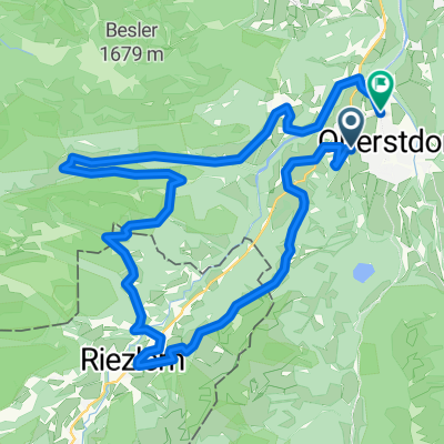
Overview
About this route
An der Iller von Oberstdorf nach Kempten
- -:--
- Duration
- 44.2 km
- Distance
- 44 m
- Ascent
- 183 m
- Descent
- ---
- Avg. speed
- ---
- Max. altitude
Continue with Bikemap
Use, edit, or download this cycling route
You would like to ride Illerradweg 1 or customize it for your own trip? Here is what you can do with this Bikemap route:
Free features
- Save this route as favorite or in collections
- Copy & plan your own version of this route
- Sync your route with Garmin or Wahoo
Premium features
Free trial for 3 days, or one-time payment. More about Bikemap Premium.
- Navigate this route on iOS & Android
- Export a GPX / KML file of this route
- Create your custom printout (try it for free)
- Download this route for offline navigation
Discover more Premium features.
Get Bikemap PremiumFrom our community
Other popular routes starting in Oberstdorf
 Transalp Oberstdorf - Stilfserjoch - Laas
- Distance
- 289.9 km
- Ascent
- 7,211 m
- Descent
- 7,110 m
- Location
- Oberstdorf, Bavaria, Germany
 Oberstdorf Marathon 2015 Mittelstrecke
- Distance
- 32.2 km
- Ascent
- 733 m
- Descent
- 735 m
- Location
- Oberstdorf, Bavaria, Germany
 Transalp Etappe 1: Oberstdorf - Dalaas
- Distance
- 55.4 km
- Ascent
- 1,503 m
- Descent
- 1,458 m
- Location
- Oberstdorf, Bavaria, Germany
 7) Radtour Kleinwalsertal
- Distance
- 34.1 km
- Ascent
- 899 m
- Descent
- 902 m
- Location
- Oberstdorf, Bavaria, Germany
 Oberstdorf - Rohrmoostal - Lecknertal
- Distance
- 74.8 km
- Ascent
- 1,190 m
- Descent
- 1,190 m
- Location
- Oberstdorf, Bavaria, Germany
 Oberstdorf - Käseralpe
- Distance
- 22.8 km
- Ascent
- 631 m
- Descent
- 630 m
- Location
- Oberstdorf, Bavaria, Germany
 MTB Oberstdorf - DAY_5 (6_2009) - Kanzelwand
- Distance
- 43.4 km
- Ascent
- 1,377 m
- Descent
- 1,377 m
- Location
- Oberstdorf, Bavaria, Germany
 Balderschwang Riedbergpass
- Distance
- 50.1 km
- Ascent
- 1,065 m
- Descent
- 1,065 m
- Location
- Oberstdorf, Bavaria, Germany
Open it in the app