

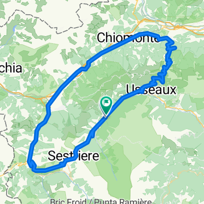
Pragelato - Sestriere - Meana di Susa - Colle delle Finestre - Usseaux - Pragelato
A cycling route starting in Pragelato, Piedmont, Italy.
Overview
About this route
Pragelato - Sestriere - Meana di Susa - Colle delle Finestre - Usseaux - Pragelato
- -:--
- Duration
- 91.2 km
- Distance
- 2,135 m
- Ascent
- 2,137 m
- Descent
- ---
- Avg. speed
- ---
- Max. altitude
Route quality
Waytypes & surfaces along the route
Waytypes
Quiet road
36.5 km
(40 %)
Access road
0.9 km
(1 %)
Surfaces
Paved
81.1 km
(89 %)
Unpaved
7.3 km
(8 %)
Asphalt
81.1 km
(89 %)
Gravel
7.3 km
(8 %)
Undefined
2.7 km
(3 %)
Continue with Bikemap
Use, edit, or download this cycling route
You would like to ride Pragelato - Sestriere - Meana di Susa - Colle delle Finestre - Usseaux - Pragelato or customize it for your own trip? Here is what you can do with this Bikemap route:
Free features
- Save this route as favorite or in collections
- Copy & plan your own version of this route
- Split it into stages to create a multi-day tour
- Sync your route with Garmin or Wahoo
Premium features
Free trial for 3 days, or one-time payment. More about Bikemap Premium.
- Navigate this route on iOS & Android
- Export a GPX / KML file of this route
- Create your custom printout (try it for free)
- Download this route for offline navigation
Discover more Premium features.
Get Bikemap PremiumFrom our community
Other popular routes starting in Pragelato
 Tour delle Alpi Olimpiche - Olympic Alps Tour
- Distance
- 113.1 km
- Ascent
- 2,343 m
- Descent
- 2,343 m
- Location
- Pragelato, Piedmont, Italy
 Pragelato - La Vachette
- Distance
- 78.5 km
- Ascent
- 2,164 m
- Descent
- 2,163 m
- Location
- Pragelato, Piedmont, Italy
 Sestriere (e20 Giro)
- Distance
- 10.5 km
- Ascent
- 528 m
- Descent
- 0 m
- Location
- Pragelato, Piedmont, Italy
 Pragelato - Sestriere - Meana di Susa - Colle delle Finestre - Usseaux - Pragelato
- Distance
- 91.2 km
- Ascent
- 2,135 m
- Descent
- 2,137 m
- Location
- Pragelato, Piedmont, Italy
 5-Soucheres Basses-Bessans (Finestre-Mont Cenis)
- Distance
- 83.4 km
- Ascent
- 2,950 m
- Descent
- 2,706 m
- Location
- Pragelato, Piedmont, Italy
 Pragelato - Les Deux Alpes-Glacier du Mont Lans
- Distance
- 276.8 km
- Ascent
- 7,733 m
- Descent
- 6,112 m
- Location
- Pragelato, Piedmont, Italy
 Val Troncea
- Distance
- 20.9 km
- Ascent
- 560 m
- Descent
- 598 m
- Location
- Pragelato, Piedmont, Italy
 Pragelato - Militare - Setriere - Borgata - Plan - Pragelato
- Distance
- 32 km
- Ascent
- 1,206 m
- Descent
- 1,206 m
- Location
- Pragelato, Piedmont, Italy
Open it in the app