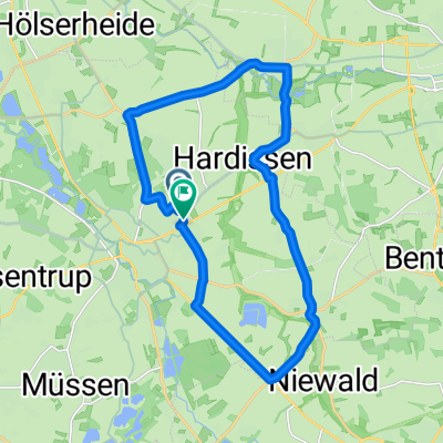
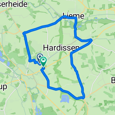
Bismarcktour
A cycling route starting in Lage, North Rhine-Westphalia, Germany.
Overview
About this route
.
(cloned from route 2447821)
- -:--
- Duration
- 52.9 km
- Distance
- 568 m
- Ascent
- 565 m
- Descent
- ---
- Avg. speed
- ---
- Max. altitude
Route quality
Waytypes & surfaces along the route
Waytypes
Track
17.8 km
(34 %)
Path
14.1 km
(27 %)
Surfaces
Paved
28.2 km
(53 %)
Unpaved
21.3 km
(40 %)
Asphalt
25 km
(47 %)
Gravel
9.3 km
(18 %)
Route highlights
Points of interest along the route
Point of interest after 13.5 km
Bismarckturm auf dem Vierenberg in Bad Salzuflen
Point of interest after 23.5 km
Bismarckturm auf dem Stuckenberg in Herford
Continue with Bikemap
Use, edit, or download this cycling route
You would like to ride Bismarcktour or customize it for your own trip? Here is what you can do with this Bikemap route:
Free features
- Save this route as favorite or in collections
- Copy & plan your own version of this route
- Sync your route with Garmin or Wahoo
Premium features
Free trial for 3 days, or one-time payment. More about Bikemap Premium.
- Navigate this route on iOS & Android
- Export a GPX / KML file of this route
- Create your custom printout (try it for free)
- Download this route for offline navigation
Discover more Premium features.
Get Bikemap PremiumFrom our community
Other popular routes starting in Lage
- Sonntagmorgen Rundtour zum Skypoint Detmold und zurück.
- Distance
- 25.8 km
- Ascent
- 114 m
- Descent
- 113 m
- Location
- Lage, North Rhine-Westphalia, Germany
- Lage Hörste Herrmann bikemap
- Distance
- 39.3 km
- Ascent
- 646 m
- Descent
- 529 m
- Location
- Lage, North Rhine-Westphalia, Germany
- OWL Lippe: Hermann-Gauseköte-Oerlinghausen
- Distance
- 87.1 km
- Ascent
- 772 m
- Descent
- 772 m
- Location
- Lage, North Rhine-Westphalia, Germany
- Lage Hermannsdenkmal
- Distance
- 28.7 km
- Ascent
- 386 m
- Descent
- 385 m
- Location
- Lage, North Rhine-Westphalia, Germany
- Von Lage zur Stadthalle in Bielefeld und über Bad Salzuflen zurück
- Distance
- 54.4 km
- Ascent
- 191 m
- Descent
- 193 m
- Location
- Lage, North Rhine-Westphalia, Germany
- Sightseeing: Lage-BS-Kirchheide-Vlotho-Kalletal-Hollenstein
- Distance
- 70 km
- Ascent
- 620 m
- Descent
- 593 m
- Location
- Lage, North Rhine-Westphalia, Germany
- MTB Teutoburgerwald
- Distance
- 40.5 km
- Ascent
- 614 m
- Descent
- 614 m
- Location
- Lage, North Rhine-Westphalia, Germany
- zu den Externsteinen
- Distance
- 43.8 km
- Ascent
- 243 m
- Descent
- 243 m
- Location
- Lage, North Rhine-Westphalia, Germany
Open it in the app