

UltraMTB 2015 - Categoria PRÓ
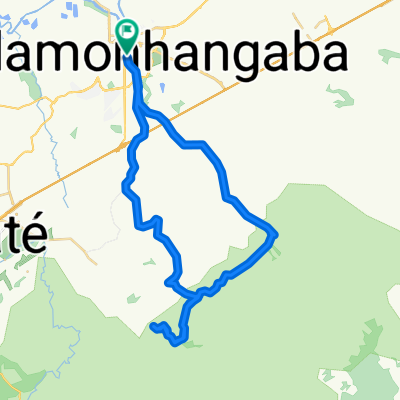
A cycling route starting in Pindamonhangaba, São Paulo, Brazil.
Overview
About this route
1st stage UltraMTB Marathon of Mountain Bike 2015. Stage Serra da Mantiqueira. March 8, Location: Start/Finish = Restaurante Colmeia, estrada do Ribeirão Grande, Pindamonhangaba-SP.
- -:--
- Duration
- 56.1 km
- Distance
- 739 m
- Ascent
- 739 m
- Descent
- ---
- Avg. speed
- ---
- Max. altitude

Route quality
Waytypes & surfaces along the route
Waytypes
Quiet road
51.6 km
(92 %)
Road
4.5 km
(8 %)
Surfaces
Paved
3.4 km
(6 %)
Unpaved
15.7 km
(28 %)
Unpaved (undefined)
15.7 km
(28 %)
Asphalt
3.4 km
(6 %)
Undefined
37 km
(66 %)
Continue with Bikemap
Use, edit, or download this cycling route
You would like to ride UltraMTB 2015 - Categoria PRÓ or customize it for your own trip? Here is what you can do with this Bikemap route:
Free features
- Save this route as favorite or in collections
- Copy & plan your own version of this route
- Sync your route with Garmin or Wahoo
Premium features
Free trial for 3 days, or one-time payment. More about Bikemap Premium.
- Navigate this route on iOS & Android
- Export a GPX / KML file of this route
- Create your custom printout (try it for free)
- Download this route for offline navigation
Discover more Premium features.
Get Bikemap PremiumFrom our community
Other popular routes starting in Pindamonhangaba
 Percurso Categoria SPORT 50KM OFICIAL
- Distance
- 54.9 km
- Ascent
- 485 m
- Descent
- 485 m
- Location
- Pindamonhangaba, São Paulo, Brazil
 TREINÃO REI E RAINHA DA MONTANHA
- Distance
- 12.2 km
- Ascent
- 925 m
- Descent
- 271 m
- Location
- Pindamonhangaba, São Paulo, Brazil
 Pinda a Aparecida (Trilha) CLONED FROM ROUTE 1873654
- Distance
- 42.9 km
- Ascent
- 189 m
- Descent
- 183 m
- Location
- Pindamonhangaba, São Paulo, Brazil
 UltraMTB 2015 - Categoria PRÓ
- Distance
- 56.1 km
- Ascent
- 739 m
- Descent
- 739 m
- Location
- Pindamonhangaba, São Paulo, Brazil
 Pedal ICPinda X Estrada do Borba X Serrinha X Estrada Pinhão do Borba
- Distance
- 54 km
- Ascent
- 683 m
- Descent
- 683 m
- Location
- Pindamonhangaba, São Paulo, Brazil
 Percurso categoria LIGHT 25KM OFICIAL
- Distance
- 26.1 km
- Ascent
- 160 m
- Descent
- 162 m
- Location
- Pindamonhangaba, São Paulo, Brazil
 Percurso Categoria PRÓ OFICIAL 2012
- Distance
- 65.8 km
- Ascent
- 683 m
- Descent
- 683 m
- Location
- Pindamonhangaba, São Paulo, Brazil
 1ª Etapa UltraMTB Pró
- Distance
- 68.8 km
- Ascent
- 995 m
- Descent
- 995 m
- Location
- Pindamonhangaba, São Paulo, Brazil
Open it in the app