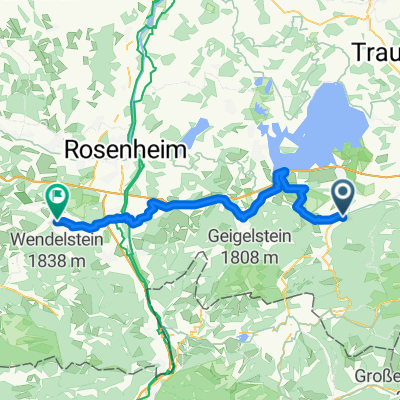
Achental-Radweg
A cycling route starting in Staudach-Egerndach, Bavaria, Germany.
Overview
About this route
beschreibung folgt
- -:--
- Duration
- 59.8 km
- Distance
- 170 m
- Ascent
- 172 m
- Descent
- ---
- Avg. speed
- ---
- Avg. speed
Route quality
Waytypes & surfaces along the route
Waytypes
Track
23.4 km
(39 %)
Quiet road
23.3 km
(39 %)
Surfaces
Paved
36.1 km
(60 %)
Unpaved
22.9 km
(38 %)
Asphalt
35.2 km
(59 %)
Gravel
16.3 km
(27 %)
Continue with Bikemap
Use, edit, or download this cycling route
You would like to ride Achental-Radweg or customize it for your own trip? Here is what you can do with this Bikemap route:
Free features
- Save this route as favorite or in collections
- Copy & plan your own version of this route
- Sync your route with Garmin or Wahoo
Premium features
Free trial for 3 days, or one-time payment. More about Bikemap Premium.
- Navigate this route on iOS & Android
- Export a GPX / KML file of this route
- Create your custom printout (try it for free)
- Download this route for offline navigation
Discover more Premium features.
Get Bikemap PremiumFrom our community
Other popular routes starting in Staudach-Egerndach
- bayern zinnkopf
- Distance
- 52 km
- Ascent
- 1,176 m
- Descent
- 1,176 m
- Location
- Staudach-Egerndach, Bavaria, Germany
- Wandern Vorderalm-Brachtalm-Schnappenkirche
- Distance
- 11.1 km
- Ascent
- 675 m
- Descent
- 675 m
- Location
- Staudach-Egerndach, Bavaria, Germany
- rund um den hochgern
- Distance
- 37.2 km
- Ascent
- 859 m
- Descent
- 860 m
- Location
- Staudach-Egerndach, Bavaria, Germany
- Chiemgau Runde
- Distance
- 73.4 km
- Ascent
- 1,155 m
- Descent
- 1,120 m
- Location
- Staudach-Egerndach, Bavaria, Germany
- Rottau Maisalm
- Distance
- 40.7 km
- Ascent
- 1,217 m
- Descent
- 1,211 m
- Location
- Staudach-Egerndach, Bavaria, Germany
- Rundkurs im Winkel
- Distance
- 72.4 km
- Ascent
- 943 m
- Descent
- 943 m
- Location
- Staudach-Egerndach, Bavaria, Germany
- BK01g Staudach-Egerndach Ortseingang - Pension Zum Ott
- Distance
- 1.2 km
- Ascent
- 21 m
- Descent
- 13 m
- Location
- Staudach-Egerndach, Bavaria, Germany
- Bergener MTB-Runde
- Distance
- 23.8 km
- Ascent
- 1,033 m
- Descent
- 1,001 m
- Location
- Staudach-Egerndach, Bavaria, Germany
Open it in the app