

Kraków-Bibice-Węgrzce- Raciborowice
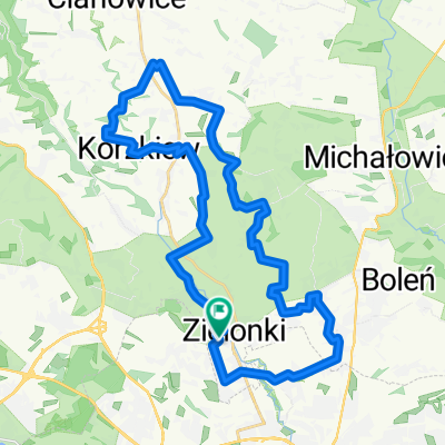
A cycling route starting in Zielonki, Lesser Poland Voivodeship, Poland.
Overview
About this route
The trail is a branch of the red Kościuszko trail, providing a connection to Krakow (with Prądnik Biały). It shares a common route with other trails over quite significant sections. In the network of trails in the municipality of Zielonki, it creates an important cycling connection from the southern part of Bibic through Węgrzce to Bosutów.
- -:--
- Duration
- 13 km
- Distance
- 155 m
- Ascent
- 142 m
- Descent
- ---
- Avg. speed
- ---
- Max. altitude
Route highlights
Points of interest along the route

Point of interest after 9.5 km
Obelisk Kościuszkowski
Continue with Bikemap
Use, edit, or download this cycling route
You would like to ride Kraków-Bibice-Węgrzce- Raciborowice or customize it for your own trip? Here is what you can do with this Bikemap route:
Free features
- Save this route as favorite or in collections
- Copy & plan your own version of this route
- Sync your route with Garmin or Wahoo
Premium features
Free trial for 3 days, or one-time payment. More about Bikemap Premium.
- Navigate this route on iOS & Android
- Export a GPX / KML file of this route
- Create your custom printout (try it for free)
- Download this route for offline navigation
Discover more Premium features.
Get Bikemap PremiumFrom our community
Other popular routes starting in Zielonki
 KRAKÓW 2011: Kraków - Zielonki - Pękowice - Giebułtów - Dolina Pradnika - Ojcowski Park Narodowy
- Distance
- 18.6 km
- Ascent
- 292 m
- Descent
- 170 m
- Location
- Zielonki, Lesser Poland Voivodeship, Poland
 VI Rajd po gminie Zielonki
- Distance
- 30.5 km
- Ascent
- 394 m
- Descent
- 391 m
- Location
- Zielonki, Lesser Poland Voivodeship, Poland
 pętelka na północ 105 k
- Distance
- 104.6 km
- Ascent
- 1,422 m
- Descent
- 1,411 m
- Location
- Zielonki, Lesser Poland Voivodeship, Poland
 Wola Zachariaszowska - Witkowice
- Distance
- 7 km
- Ascent
- 36 m
- Descent
- 110 m
- Location
- Zielonki, Lesser Poland Voivodeship, Poland
 SkalaPetelka
- Distance
- 40.7 km
- Ascent
- 275 m
- Descent
- 276 m
- Location
- Zielonki, Lesser Poland Voivodeship, Poland
 Zielonki (szlak okrężny)
- Distance
- 32.6 km
- Ascent
- 351 m
- Descent
- 353 m
- Location
- Zielonki, Lesser Poland Voivodeship, Poland
 Treningo-wycieczka MTB na Pustynię Błędowską
- Distance
- 114.7 km
- Ascent
- 783 m
- Descent
- 783 m
- Location
- Zielonki, Lesser Poland Voivodeship, Poland
 Zimowo super zamrożone.
- Distance
- 54 km
- Ascent
- 489 m
- Descent
- 487 m
- Location
- Zielonki, Lesser Poland Voivodeship, Poland
Open it in the app