

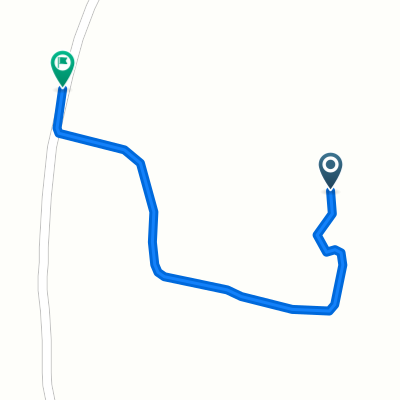
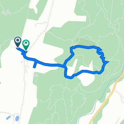
Willoughby 50
A cycling route starting in Lyndonville, Vermont, United States.
Overview
About this route
one lake
- -:--
- Duration
- 50.5 km
- Distance
- 371 m
- Ascent
- 371 m
- Descent
- ---
- Avg. speed
- ---
- Max. altitude

Route quality
Waytypes & surfaces along the route
Waytypes
Road
11.1 km
(22 %)
Undefined
39.4 km
(78 %)
Surfaces
Paved
50.5 km
(100 %)
Asphalt
50.5 km
(100 %)
Continue with Bikemap
Use, edit, or download this cycling route
You would like to ride Willoughby 50 or customize it for your own trip? Here is what you can do with this Bikemap route:
Free features
- Save this route as favorite or in collections
- Copy & plan your own version of this route
- Sync your route with Garmin or Wahoo
Premium features
Free trial for 3 days, or one-time payment. More about Bikemap Premium.
- Navigate this route on iOS & Android
- Export a GPX / KML file of this route
- Create your custom printout (try it for free)
- Download this route for offline navigation
Discover more Premium features.
Get Bikemap PremiumFrom our community
Other popular routes starting in Lyndonville
 Recovered Route
- Distance
- 2.8 km
- Ascent
- 40 m
- Descent
- 81 m
- Location
- Lyndonville, Vermont, United States
 Willoughby 50
- Distance
- 50.5 km
- Ascent
- 371 m
- Descent
- 371 m
- Location
- Lyndonville, Vermont, United States
 the Wildflower Inn to Potton
- Distance
- 98.6 km
- Ascent
- 1,519 m
- Descent
- 1,507 m
- Location
- Lyndonville, Vermont, United States
 Cherry Lane to Cherry Lane
- Distance
- 0.8 km
- Ascent
- 34 m
- Descent
- 18 m
- Location
- Lyndonville, Vermont, United States
 Burke to Maple Ridge AM ride
- Distance
- 23.6 km
- Ascent
- 422 m
- Descent
- 422 m
- Location
- Lyndonville, Vermont, United States
 Route to 2261 Darling Hill Rd, Lyndonville
- Distance
- 4.1 km
- Ascent
- 110 m
- Descent
- 97 m
- Location
- Lyndonville, Vermont, United States
 Moriah’s Ascent (one way)
- Distance
- 1 km
- Ascent
- 54 m
- Descent
- 4 m
- Location
- Lyndonville, Vermont, United States
 1219–1399 Kirby Rd, East Burke to 39 Main St, Montpelier
- Distance
- 81.5 km
- Ascent
- 520 m
- Descent
- 744 m
- Location
- Lyndonville, Vermont, United States
Open it in the app