

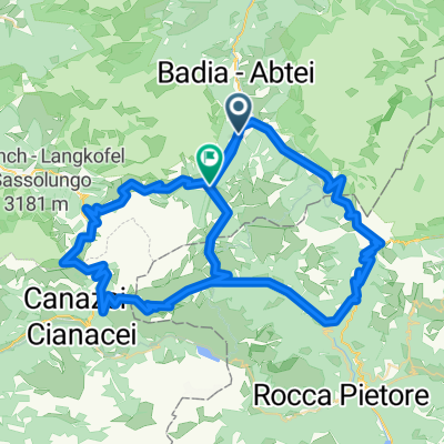
Giro del Fanes
A cycling route starting in Abtei-Badia, Trentino-Alto Adige, Italy.
Overview
About this route
Strenuous but unmissable itinerary around the 'Croda di Santa Croce' and in the Fanes Natural Park.
The section from Badia (Pedraces) to the Nagler hut is covered by the first chairlift enabled for bike transport, but it can also be done by following the service road...
- -:--
- Duration
- 55.3 km
- Distance
- 1,543 m
- Ascent
- 2,048 m
- Descent
- ---
- Avg. speed
- ---
- Max. altitude
Continue with Bikemap
Use, edit, or download this cycling route
You would like to ride Giro del Fanes or customize it for your own trip? Here is what you can do with this Bikemap route:
Free features
- Save this route as favorite or in collections
- Copy & plan your own version of this route
- Sync your route with Garmin or Wahoo
Premium features
Free trial for 3 days, or one-time payment. More about Bikemap Premium.
- Navigate this route on iOS & Android
- Export a GPX / KML file of this route
- Create your custom printout (try it for free)
- Download this route for offline navigation
Discover more Premium features.
Get Bikemap PremiumFrom our community
Other popular routes starting in Abtei-Badia
 Medium DOLOMITI
- Distance
- 113.4 km
- Ascent
- 4,347 m
- Descent
- 4,252 m
- Location
- Abtei-Badia, Trentino-Alto Adige, Italy
 Maratona dles Dolomites 2008, mittlere Runde
- Distance
- 103 km
- Ascent
- 3,096 m
- Descent
- 2,950 m
- Location
- Abtei-Badia, Trentino-Alto Adige, Italy
 Maratona dles Dolomites
- Distance
- 137.5 km
- Ascent
- 3,883 m
- Descent
- 3,539 m
- Location
- Abtei-Badia, Trentino-Alto Adige, Italy
 hotel-linder-neu-groeden-pralongia-hochplateau - proposed
- Distance
- 45.5 km
- Ascent
- 2,099 m
- Descent
- 2,099 m
- Location
- Abtei-Badia, Trentino-Alto Adige, Italy
 Kirche San Leonardo - Kirche Heilig Kreuz
- Distance
- 15.8 km
- Ascent
- 933 m
- Descent
- 933 m
- Location
- Abtei-Badia, Trentino-Alto Adige, Italy
 alta Badia Fanes 58-1800
- Distance
- 57.8 km
- Ascent
- 1,694 m
- Descent
- 1,698 m
- Location
- Abtei-Badia, Trentino-Alto Adige, Italy
 SuperMaratona DOLOMITI
- Distance
- 294.1 km
- Ascent
- 10,966 m
- Descent
- 10,765 m
- Location
- Abtei-Badia, Trentino-Alto Adige, Italy
 Strada Armuntarora nach Passo Falzarego
- Distance
- 11.6 km
- Ascent
- 701 m
- Descent
- 139 m
- Location
- Abtei-Badia, Trentino-Alto Adige, Italy
Open it in the app