

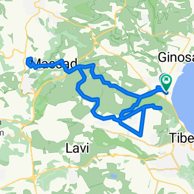
מסלול הגולדן רינג - סובב כנרת
A cycling route starting in Teverya, Northern District, Israel.
Overview
About this route
תאור : גינוסר - צמח - מבוא חמה - אפיק - כורסי - יהודיה - גינוסר .
אורך : 90 ק"מ . גובה :- -:--
- Duration
- 82.5 km
- Distance
- 415 m
- Ascent
- 415 m
- Descent
- ---
- Avg. speed
- ---
- Max. altitude
Uzi Liraz

created this 10 years ago
Continue with Bikemap
Use, edit, or download this cycling route
You would like to ride מסלול הגולדן רינג - סובב כנרת or customize it for your own trip? Here is what you can do with this Bikemap route:
Free features
- Save this route as favorite or in collections
- Copy & plan your own version of this route
- Split it into stages to create a multi-day tour
- Sync your route with Garmin or Wahoo
Premium features
Free trial for 3 days, or one-time payment. More about Bikemap Premium.
- Navigate this route on iOS & Android
- Export a GPX / KML file of this route
- Create your custom printout (try it for free)
- Download this route for offline navigation
Discover more Premium features.
Get Bikemap PremiumFrom our community
Other popular routes starting in Teverya
- 티베리아(양) 갈릴리 벳산
- 104.1 km
- 0 m
- 0 m
- Teverya, Northern District, Israel
- 77 - Tabgha a Nazareth
- 44 km
- 648 m
- 228 m
- Teverya, Northern District, Israel
- nazareth
- 32.6 km
- 600 m
- 233 m
- Teverya, Northern District, Israel
- Route in Migdal
- 42 km
- 918 m
- 916 m
- Teverya, Northern District, Israel
- 2019TC3
- 86.7 km
- 1,024 m
- 1,024 m
- Teverya, Northern District, Israel
- 2025-08-12 13:59
- 35.2 km
- 985 m
- 986 m
- Teverya, Northern District, Israel
- שוויץ ניקי-21
- 20.1 km
- 585 m
- 585 m
- Teverya, Northern District, Israel


Open it in the app