

Self-propelling particle
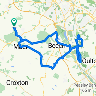
A cycling route starting in Standon, England, United Kingdom.
Overview
About this route
Day 1
- -:--
- Duration
- 62.3 km
- Distance
- 186 m
- Ascent
- 324 m
- Descent
- ---
- Avg. speed
- ---
- Max. altitude

Route quality
Waytypes & surfaces along the route
Waytypes
Road
22.4 km
(36 %)
Cycleway
6.9 km
(11 %)
Surfaces
Paved
15 km
(24 %)
Asphalt
14.3 km
(23 %)
Paved (undefined)
0.6 km
(1 %)
Undefined
47.4 km
(76 %)
Continue with Bikemap
Use, edit, or download this cycling route
You would like to ride Self-propelling particle or customize it for your own trip? Here is what you can do with this Bikemap route:
Free features
- Save this route as favorite or in collections
- Copy & plan your own version of this route
- Sync your route with Garmin or Wahoo
Premium features
Free trial for 3 days, or one-time payment. More about Bikemap Premium.
- Navigate this route on iOS & Android
- Export a GPX / KML file of this route
- Create your custom printout (try it for free)
- Download this route for offline navigation
Discover more Premium features.
Get Bikemap PremiumFrom our community
Other popular routes starting in Standon
 Swynnerton to Woore
- Distance
- 70.9 km
- Ascent
- 301 m
- Descent
- 305 m
- Location
- Standon, England, United Kingdom
 Springfields, Wesleyan Road, Market Drayton to 15 Welby St, Stoke-On-Trent
- Distance
- 18.5 km
- Ascent
- 172 m
- Descent
- 226 m
- Location
- Standon, England, United Kingdom
 Park Wood Drive, Newcastle to Park Wood Drive, Newcastle
- Distance
- 46.5 km
- Ascent
- 545 m
- Descent
- 549 m
- Location
- Standon, England, United Kingdom
 LEJOG Day 6
- Distance
- 159.8 km
- Ascent
- 317 m
- Descent
- 524 m
- Location
- Standon, England, United Kingdom
 Recovered Route
- Distance
- 35.2 km
- Ascent
- 431 m
- Descent
- 427 m
- Location
- Standon, England, United Kingdom
 Norbury Junction
- Distance
- 54.1 km
- Ascent
- 252 m
- Descent
- 252 m
- Location
- Standon, England, United Kingdom
 Church Road, Market Drayton to 118 Foley Road, Stoke-on-Trent
- Distance
- 24.8 km
- Ascent
- 210 m
- Descent
- 230 m
- Location
- Standon, England, United Kingdom
 Swynners Woore
- Distance
- 80.4 km
- Ascent
- 351 m
- Descent
- 358 m
- Location
- Standon, England, United Kingdom
Open it in the app