
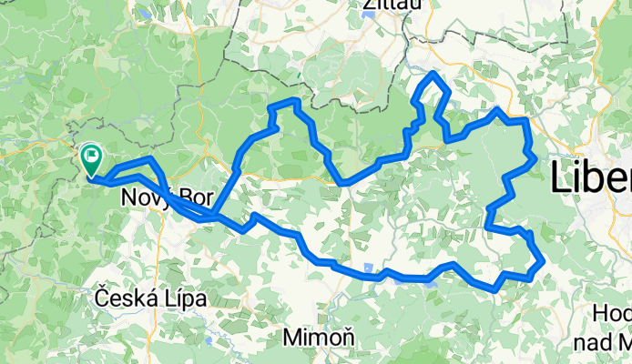
Svobodak - kopce
A cycling route starting in Česká Kamenice, Ústecký kraj, Czechia.
Overview
About this route
Malevil, Kryštof, Ještěd, Stráž, Nový Bor
- -:--
- Duration
- 128.3 km
- Distance
- 1,473 m
- Ascent
- 1,458 m
- Descent
- ---
- Avg. speed
- ---
- Max. altitude
Route quality
Waytypes & surfaces along the route
Waytypes
Road
72.7 km
(57 %)
Busy road
35.3 km
(28 %)
Surfaces
Paved
82.7 km
(64 %)
Asphalt
82.7 km
(64 %)
Paved (undefined)
0 km
(<1 %)
Undefined
45.6 km
(36 %)
Continue with Bikemap
Use, edit, or download this cycling route
You would like to ride Svobodak - kopce or customize it for your own trip? Here is what you can do with this Bikemap route:
Free features
- Save this route as favorite or in collections
- Copy & plan your own version of this route
- Split it into stages to create a multi-day tour
- Sync your route with Garmin or Wahoo
Premium features
Free trial for 3 days, or one-time payment. More about Bikemap Premium.
- Navigate this route on iOS & Android
- Export a GPX / KML file of this route
- Create your custom printout (try it for free)
- Download this route for offline navigation
Discover more Premium features.
Get Bikemap PremiumFrom our community
Other popular routes starting in Česká Kamenice
 Testovací č.1
- Distance
- 20.1 km
- Ascent
- 190 m
- Descent
- 193 m
- Location
- Česká Kamenice, Ústecký kraj, Czechia
 Trasa ČESKOSASKÉ ŠVÝCARSKO NA KOLE - www.nomad.cz
- Distance
- 233.5 km
- Ascent
- 1,601 m
- Descent
- 1,604 m
- Location
- Česká Kamenice, Ústecký kraj, Czechia
 České Švýcarsko 01
- Distance
- 49.5 km
- Ascent
- 616 m
- Descent
- 616 m
- Location
- Česká Kamenice, Ústecký kraj, Czechia
 České Švýcarsko 02
- Distance
- 56.2 km
- Ascent
- 434 m
- Descent
- 434 m
- Location
- Česká Kamenice, Ústecký kraj, Czechia
 Tagestour Vysoka Lipa-Rynartice-Chrbska-Ceska Kamenice-Studeny-Rynartice-Vysoka Lipa
- Distance
- 41.4 km
- Ascent
- 704 m
- Descent
- 690 m
- Location
- Česká Kamenice, Ústecký kraj, Czechia
 4. Panská skála - Ještěd
- Distance
- 50.5 km
- Ascent
- 782 m
- Descent
- 400 m
- Location
- Česká Kamenice, Ústecký kraj, Czechia
 Fofr Cup - MTB marathon
- Distance
- 29.8 km
- Ascent
- 603 m
- Descent
- 603 m
- Location
- Česká Kamenice, Ústecký kraj, Czechia
 2005-05-16 Vysoká Lípa-Hinterhermsdorf-Kyjov-Doubice-V.L
- Distance
- 40 km
- Ascent
- 625 m
- Descent
- 631 m
- Location
- Česká Kamenice, Ústecký kraj, Czechia
Open it in the app