

Lingen-Br. Elberger Schlipse Rundkurs
A cycling route starting in Lünne, Lower Saxony, Germany.
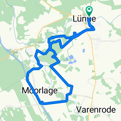
Overview
About this route
Einfache Strecke. 1 km an der Bundesstraße, ca. 2,5 km über einen Waldweg und ca. 2 km am Kanal über einen Schotterweg.
An der B 70 die Straßenseite bei der Fußgängerampel wechseln.- -:--
- Duration
- 22.2 km
- Distance
- 99 m
- Ascent
- 99 m
- Descent
- ---
- Avg. speed
- ---
- Max. altitude
Route quality
Waytypes & surfaces along the route
Waytypes
Quiet road
9.3 km
(42 %)
Track
5.8 km
(26 %)
Surfaces
Paved
12.9 km
(58 %)
Unpaved
5.6 km
(25 %)
Asphalt
11.3 km
(51 %)
Ground
2.7 km
(12 %)
Continue with Bikemap
Use, edit, or download this cycling route
You would like to ride Lingen-Br. Elberger Schlipse Rundkurs or customize it for your own trip? Here is what you can do with this Bikemap route:
Free features
- Save this route as favorite or in collections
- Copy & plan your own version of this route
- Sync your route with Garmin or Wahoo
Premium features
Free trial for 3 days, or one-time payment. More about Bikemap Premium.
- Navigate this route on iOS & Android
- Export a GPX / KML file of this route
- Create your custom printout (try it for free)
- Download this route for offline navigation
Discover more Premium features.
Get Bikemap PremiumFrom our community
Other popular routes starting in Lünne
 Esens
Esens- Distance
- 192.2 km
- Ascent
- 56 m
- Descent
- 91 m
- Location
- Lünne, Lower Saxony, Germany
 Womo-Moorlage-Dortmund -Emskanal-Ems-Womo
- Distance
- 19.3 km
- Ascent
- 80 m
- Descent
- 80 m
- Location
- Lünne, Lower Saxony, Germany
 Bramsche Rundtour Listruper Wehr
- Distance
- 20.5 km
- Ascent
- 71 m
- Descent
- 70 m
- Location
- Lünne, Lower Saxony, Germany
 Lingen-Br.Messingen, Baccum, Mundersum
- Distance
- 24.6 km
- Ascent
- 66 m
- Descent
- 67 m
- Location
- Lünne, Lower Saxony, Germany
 Lingen-Br. Hesselte, Schleuse Venhaus, Lünne
- Distance
- 26.3 km
- Ascent
- 55 m
- Descent
- 52 m
- Location
- Lünne, Lower Saxony, Germany
 Wintermanns Tannen
- Distance
- 20 km
- Ascent
- 527 m
- Descent
- 522 m
- Location
- Lünne, Lower Saxony, Germany
 Aatal und Moor -Route
- Distance
- 47.3 km
- Ascent
- 35 m
- Descent
- 38 m
- Location
- Lünne, Lower Saxony, Germany
 Rundkurs Lohner See
- Distance
- 41.2 km
- Ascent
- 72 m
- Descent
- 74 m
- Location
- Lünne, Lower Saxony, Germany
Open it in the app