

Leiston
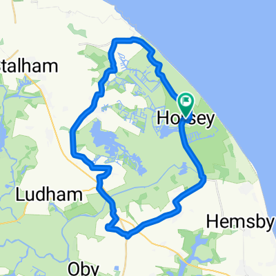
A cycling route starting in Martham, England, United Kingdom.
Overview
About this route
Thurne-Leiston
- -:--
- Duration
- 107 km
- Distance
- 172 m
- Ascent
- 150 m
- Descent
- ---
- Avg. speed
- ---
- Max. altitude

Route quality
Waytypes & surfaces along the route
Waytypes
Quiet road
55.7 km
(52 %)
Road
19.3 km
(18 %)
Surfaces
Paved
26.8 km
(25 %)
Unpaved
2.1 km
(2 %)
Asphalt
23.5 km
(22 %)
Paved (undefined)
3.2 km
(3 %)
Continue with Bikemap
Use, edit, or download this cycling route
You would like to ride Leiston or customize it for your own trip? Here is what you can do with this Bikemap route:
Free features
- Save this route as favorite or in collections
- Copy & plan your own version of this route
- Split it into stages to create a multi-day tour
- Sync your route with Garmin or Wahoo
Premium features
Free trial for 3 days, or one-time payment. More about Bikemap Premium.
- Navigate this route on iOS & Android
- Export a GPX / KML file of this route
- Create your custom printout (try it for free)
- Download this route for offline navigation
Discover more Premium features.
Get Bikemap PremiumFrom our community
Other popular routes starting in Martham
 Horsey loop
- Distance
- 30.7 km
- Ascent
- 37 m
- Descent
- 40 m
- Location
- Martham, England, United Kingdom
 Waxham Sands to Sugar'n Spice Café at Bacton and return
- Distance
- 52.9 km
- Ascent
- 121 m
- Descent
- 121 m
- Location
- Martham, England, United Kingdom
 Horsey Circular
- Distance
- 32.4 km
- Ascent
- 52 m
- Descent
- 53 m
- Location
- Martham, England, United Kingdom
 Hall Cottages 2, Horsey to Hall Cottages 2, Horsey
- Distance
- 31.3 km
- Ascent
- 59 m
- Descent
- 60 m
- Location
- Martham, England, United Kingdom
 Unnamed Road to Norwich. forgot to end trip.
- Distance
- 84.9 km
- Ascent
- 303 m
- Descent
- 282 m
- Location
- Martham, England, United Kingdom
 Thurne loop 50 k
- Distance
- 56.9 km
- Ascent
- 70 m
- Descent
- 70 m
- Location
- Martham, England, United Kingdom
 Waxham Sands to Rose Tavern with detour to George Borrow Road
- Distance
- 47.7 km
- Ascent
- 106 m
- Descent
- 79 m
- Location
- Martham, England, United Kingdom
 Recovered Route
- Distance
- 35.3 km
- Ascent
- 85 m
- Descent
- 83 m
- Location
- Martham, England, United Kingdom
Open it in the app