


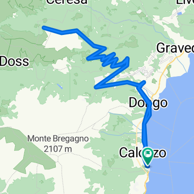
Refugio Mottafoiada
A cycling route starting in Calozzo, Lombardy, Italy.
Overview
About this route
2
Ieuppp!!!!!
- -:--
- Duration
- 44.1 km
- Distance
- 1,233 m
- Ascent
- 1,238 m
- Descent
- ---
- Avg. speed
- ---
- Max. altitude
imanolpelotok
created this 11 years ago
Route quality
Waytypes & surfaces along the route
Waytypes
Quiet road
33.5 km
76 %
Road
6.2 km
14 %
Surfaces
Paved
25.6 km
(58 %)
Unpaved
2.6 km
(6 %)
Asphalt
25.6 km
58 %
Ground
2.6 km
6 %
Undefined
15.9 km
36 %
Continue with Bikemap
Use, edit, or download this cycling route
You would like to ride Refugio Mottafoiada or customize it for your own trip? Here is what you can do with this Bikemap route:
Free features
- Save this route as favorite or in collections
- Copy & plan your own version of this route
- Sync your route with Garmin or Wahoo
Premium features
Free trial for 3 days, or one-time payment. More about Bikemap Premium.
- Navigate this route on iOS & Android
- Export a GPX / KML file of this route
- Create your custom printout (try it for free)
- Download this route for offline navigation
Discover more Premium features.
Get Bikemap PremiumFrom our community
Other popular routes starting in Calozzo


 Da Frazione Calozzo 12, Pianello del Lario a Via Tempietto 4, Tremezzina0
- 15.8 km
- 373 m
- 366 m
- Calozzo, Lombardy, Italy


Open it in the app