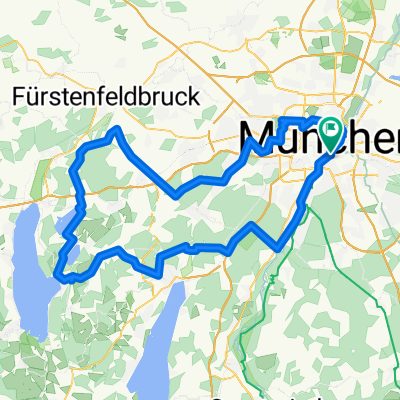
M - STA - SchÀftlarn - OHA - M
A cycling route starting in Munich, Bavaria, Germany.
Overview
About this route
Von MĂŒnchen ĂŒber die alte Starnberger Landstrasse. Links um den Starnberger See herum und ĂŒber Starnberg - SchĂ€ftlarn - Oberhaching durch den Perlacher Forst wieder nach MĂŒnchen.
- -:--
- Duration
- 110.1 km
- Distance
- 602 m
- Ascent
- 523 m
- Descent
- ---
- Avg. speed
- 667 m
- Avg. speed
Route quality
Waytypes & surfaces along the route
Waytypes
Busy road
43.6 km
(40 %)
Path
23.5 km
(21 %)
Surfaces
Paved
101.4 km
(92 %)
Unpaved
4.3 km
(4 %)
Asphalt
97 km
(88 %)
Gravel
2.4 km
(2 %)
Route highlights
Points of interest along the route
Point of interest after 34.4 km
Kleine Pause zur StÀrkung
Point of interest after 46.6 km
Zweite Pause mit Blick auf den Starnberger See
Point of interest after 46.6 km
Point of interest after 71.6 km
Wieder eine kleine Pause mit Blick auf den Starnberger See.
Point of interest after 102.2 km
Hier ist die letzte Pause vor Zuhause! ;)
Continue with Bikemap
Use, edit, or download this cycling route
You would like to ride M - STA - SchÀftlarn - OHA - M or customize it for your own trip? Here is what you can do with this Bikemap route:
Free features
- Save this route as favorite or in collections
- Copy & plan your own version of this route
- Split it into stages to create a multi-day tour
- Sync your route with Garmin or Wahoo
Premium features
Free trial for 3 days, or one-time payment. More about Bikemap Premium.
- Navigate this route on iOS & Android
- Export a GPX / KML file of this route
- Create your custom printout (try it for free)
- Download this route for offline navigation
Discover more Premium features.
Get Bikemap PremiumFrom our community
Other popular routes starting in Munich
- MĂŒnchen - BruckmĂŒhl
- Distance
- 102.8 km
- Ascent
- 609 m
- Descent
- 589 m
- Location
- Munich, Bavaria, Germany
- MĂŒnchen - Tölz - Königsdorf - MĂŒnchen
- Distance
- 124.7 km
- Ascent
- 589 m
- Descent
- 587 m
- Location
- Munich, Bavaria, Germany
- MĂŒnchen- Flughafen- MĂŒnchen
- Distance
- 131.3 km
- Ascent
- 625 m
- Descent
- 633 m
- Location
- Munich, Bavaria, Germany
- bikedress Hell of North PR 12_04_2015
- Distance
- 116.5 km
- Ascent
- 418 m
- Descent
- 417 m
- Location
- Munich, Bavaria, Germany
- Isar SĂŒd Trainings Klassiker
- Distance
- 48.2 km
- Ascent
- 345 m
- Descent
- 345 m
- Location
- Munich, Bavaria, Germany
- Walchensee Runde
- Distance
- 160.7 km
- Ascent
- 1,159 m
- Descent
- 1,008 m
- Location
- Munich, Bavaria, Germany
- mĂŒnchen - miesbach
- Distance
- 106.6 km
- Ascent
- 422 m
- Descent
- 422 m
- Location
- Munich, Bavaria, Germany
- Alpen 01 MĂŒnchen-Tölz
- Distance
- 58 km
- Ascent
- 242 m
- Descent
- 134 m
- Location
- Munich, Bavaria, Germany
Open it in the app