

Smržická šlapka CT 94km (z Myslejovic)
A cycling route starting in Otaslavice, Olomoucký kraj, Czechia.
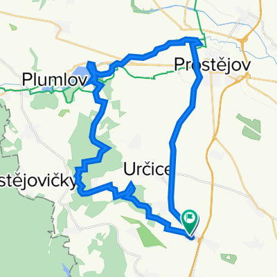
Overview
About this route
Saturday, September 5, 2009
Start: 7:00–10:00 AM at the new sports complex behind the Smržice cultural centerEntry fee: Cyclotourists measuring less than 1 meter: 10 CZK, all others: 20 CZK
- -:--
- Duration
- 123.2 km
- Distance
- 1,509 m
- Ascent
- 1,595 m
- Descent
- ---
- Avg. speed
- 695 m
- Max. altitude

Route quality
Waytypes & surfaces along the route
Waytypes
Road
76.4 km
(62 %)
Track
13.6 km
(11 %)
Surfaces
Paved
39.4 km
(32 %)
Asphalt
39.4 km
(32 %)
Undefined
83.8 km
(68 %)
Continue with Bikemap
Use, edit, or download this cycling route
You would like to ride Smržická šlapka CT 94km (z Myslejovic) or customize it for your own trip? Here is what you can do with this Bikemap route:
Free features
- Save this route as favorite or in collections
- Copy & plan your own version of this route
- Split it into stages to create a multi-day tour
- Sync your route with Garmin or Wahoo
Premium features
Free trial for 3 days, or one-time payment. More about Bikemap Premium.
- Navigate this route on iOS & Android
- Export a GPX / KML file of this route
- Create your custom printout (try it for free)
- Download this route for offline navigation
Discover more Premium features.
Get Bikemap PremiumFrom our community
Other popular routes starting in Otaslavice
 krátký okruh: Myslejovice - Žarovice - Drahany - Myslejovice
- Distance
- 34.2 km
- Ascent
- 548 m
- Descent
- 548 m
- Location
- Otaslavice, Olomoucký kraj, Czechia
 Myslejovice-Jedovnice-Rudice-Adamov-Křtiny-Ruprechtov-Pustiměř-Brodek u Prostějova-Určice-Myslejovice
- Distance
- 120.4 km
- Ascent
- 2,097 m
- Descent
- 2,139 m
- Location
- Otaslavice, Olomoucký kraj, Czechia
 Výlet do Modré
- Distance
- 113.8 km
- Ascent
- 1,283 m
- Descent
- 1,362 m
- Location
- Otaslavice, Olomoucký kraj, Czechia
 "Krátká na rozhlednu"
- Distance
- 7.1 km
- Ascent
- 92 m
- Descent
- 92 m
- Location
- Otaslavice, Olomoucký kraj, Czechia
 Smržické vandr (CT 110 km) 2011
- Distance
- 135.1 km
- Ascent
- 0 m
- Descent
- 0 m
- Location
- Otaslavice, Olomoucký kraj, Czechia
 Smržická šlapka CT 94km (z Myslejovic)
- Distance
- 123.2 km
- Ascent
- 1,509 m
- Descent
- 1,595 m
- Location
- Otaslavice, Olomoucký kraj, Czechia
 Do práce a z práce...
- Distance
- 31.6 km
- Ascent
- 346 m
- Descent
- 342 m
- Location
- Otaslavice, Olomoucký kraj, Czechia
 Vranovická
- Distance
- 29.2 km
- Ascent
- 363 m
- Descent
- 356 m
- Location
- Otaslavice, Olomoucký kraj, Czechia
Open it in the app