

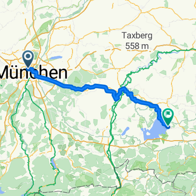
München - Rosenheim
A cycling route starting in Munich, Bavaria, Germany.
Overview
About this route
From Munich to Rosenheim along the Mangfall Cycle Path
- -:--
- Duration
- 64.2 km
- Distance
- 145 m
- Ascent
- 213 m
- Descent
- ---
- Avg. speed
- ---
- Max. altitude

Route quality
Waytypes & surfaces along the route
Waytypes
Path
28.2 km
(44 %)
Quiet road
22.5 km
(35 %)
Surfaces
Paved
48.8 km
(76 %)
Unpaved
14.1 km
(22 %)
Asphalt
48.8 km
(76 %)
Loose gravel
9.6 km
(15 %)
Continue with Bikemap
Use, edit, or download this cycling route
You would like to ride München - Rosenheim or customize it for your own trip? Here is what you can do with this Bikemap route:
Free features
- Save this route as favorite or in collections
- Copy & plan your own version of this route
- Sync your route with Garmin or Wahoo
Premium features
Free trial for 3 days, or one-time payment. More about Bikemap Premium.
- Navigate this route on iOS & Android
- Export a GPX / KML file of this route
- Create your custom printout (try it for free)
- Download this route for offline navigation
Discover more Premium features.
Get Bikemap PremiumFrom our community
Other popular routes starting in Munich
 21.6. Munich to Tegernsee
- Distance
- 77 km
- Ascent
- 883 m
- Descent
- 660 m
- Location
- Munich, Bavaria, Germany
 München - Schäftlarn - Heimathofen - München
- Distance
- 92.9 km
- Ascent
- 384 m
- Descent
- 384 m
- Location
- Munich, Bavaria, Germany
 Petra Kelly Str 22
- Distance
- 115.4 km
- Ascent
- 1,080 m
- Descent
- 1,068 m
- Location
- Munich, Bavaria, Germany
 München - Rosenheim
- Distance
- 64.2 km
- Ascent
- 145 m
- Descent
- 213 m
- Location
- Munich, Bavaria, Germany
 Runde München Starnberg - rund um den See - München
- Distance
- 95 km
- Ascent
- 335 m
- Descent
- 335 m
- Location
- Munich, Bavaria, Germany
 Münchner Norden XL (Seen und Schlösser)
- Distance
- 68.1 km
- Ascent
- 56 m
- Descent
- 59 m
- Location
- Munich, Bavaria, Germany
 Oefelestraße, München nach Falkenstraße, München
- Distance
- 19.2 km
- Ascent
- 196 m
- Descent
- 207 m
- Location
- Munich, Bavaria, Germany
 Rundfahrt München - Kloster Andechs - Wörthsee
- Distance
- 107.8 km
- Ascent
- 875 m
- Descent
- 835 m
- Location
- Munich, Bavaria, Germany
Open it in the app