

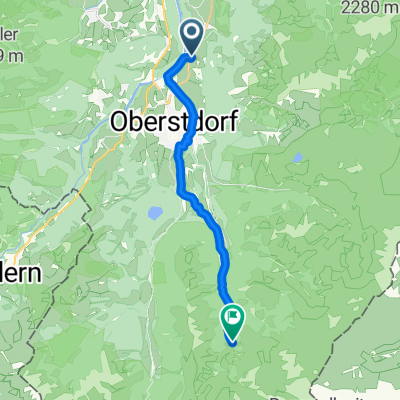
Runde zum großen Alpsee
A cycling route starting in Oberstdorf, Bavaria, Germany.
Overview
About this route
Oberstdorf, Rohrmoos, Hittisau, Krumbach, Aach, Oberstaufen, Großer Alpsee, Immenstadt, Sonthofen, Tiefenberg, Fischen, Oberstdorf
- -:--
- Duration
- 86.1 km
- Distance
- 795 m
- Ascent
- 864 m
- Descent
- ---
- Avg. speed
- ---
- Max. altitude

Route quality
Waytypes & surfaces along the route
Waytypes
Quiet road
24.1 km
(28 %)
Road
13.8 km
(16 %)
Surfaces
Paved
81.8 km
(95 %)
Unpaved
0.9 km
(1 %)
Asphalt
81.8 km
(95 %)
Gravel
0.9 km
(1 %)
Undefined
3.4 km
(4 %)
Continue with Bikemap
Use, edit, or download this cycling route
You would like to ride Runde zum großen Alpsee or customize it for your own trip? Here is what you can do with this Bikemap route:
Free features
- Save this route as favorite or in collections
- Copy & plan your own version of this route
- Split it into stages to create a multi-day tour
- Sync your route with Garmin or Wahoo
Premium features
Free trial for 3 days, or one-time payment. More about Bikemap Premium.
- Navigate this route on iOS & Android
- Export a GPX / KML file of this route
- Create your custom printout (try it for free)
- Download this route for offline navigation
Discover more Premium features.
Get Bikemap PremiumFrom our community
Other popular routes starting in Oberstdorf
 Oberstdorf - Rohrmoos
- Distance
- 25.9 km
- Ascent
- 449 m
- Descent
- 513 m
- Location
- Oberstdorf, Bavaria, Germany
 06x Oberstdorf Rundweg über Spielmannsau
- Distance
- 34.6 km
- Ascent
- 899 m
- Descent
- 898 m
- Location
- Oberstdorf, Bavaria, Germany
 Tiefenbach - Immenstadt - Oberstdorf - Tiefenbach
- Distance
- 60.6 km
- Ascent
- 345 m
- Descent
- 343 m
- Location
- Oberstdorf, Bavaria, Germany
 Oberstdorf až Walserstraße, Mittelberg
- Distance
- 6.6 km
- Ascent
- 57 m
- Descent
- 240 m
- Location
- Oberstdorf, Bavaria, Germany
 iller - Donautal 1.tag
- Distance
- 64.6 km
- Ascent
- 126 m
- Descent
- 224 m
- Location
- Oberstdorf, Bavaria, Germany
 Emmaus-Biker TransAlp2015 1. Etappe: Oberstdorf - St. Anton
- Distance
- 52.3 km
- Ascent
- 1,525 m
- Descent
- 1,044 m
- Location
- Oberstdorf, Bavaria, Germany
 Rubi nach Trettachtal
- Distance
- 13.6 km
- Ascent
- 386 m
- Descent
- 73 m
- Location
- Oberstdorf, Bavaria, Germany
 Kornau - Söllereck - Riezlern - Breitach
- Distance
- 18.2 km
- Ascent
- 775 m
- Descent
- 778 m
- Location
- Oberstdorf, Bavaria, Germany
Open it in the app