

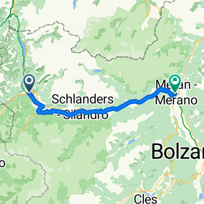
OrtlerRunde
A cycling route starting in Glurns, Trentino-Alto Adige, Italy.
Overview
About this route
n.a.
(cloned from route 3123930)
- -:--
- Duration
- 314.8 km
- Distance
- 9,655 m
- Ascent
- 9,655 m
- Descent
- ---
- Avg. speed
- ---
- Max. altitude
Route highlights
Points of interest along the route
Accommodation after 0 km
7 Hotel Krone
Accommodation after 74.5 km
1 Gletscherblick
Accommodation after 77.7 km
8 Goldene Rose
Point of interest after 93.3 km
Naturnser Alm
Point of interest after 103.3 km
Schutz Hütte
Point of interest after 104.4 km
Falkomai Alm
Point of interest after 111.1 km
Innerducharchöfe
Accommodation after 112.2 km
2 Eggwirt
Point of interest after 126.1 km
Restaurant
Point of interest after 131.1 km
Kirchbergalm
Accommodation after 135.1 km
3 Haselgruber Hütte
Point of interest after 143.6 km
Restaurant
Point of interest after 159 km
Rast
Point of interest after 168.5 km
Cashautomat
Point of interest after 182.8 km
Essen
Accommodation after 184.3 km
4 Edelweiß
Accommodation after 227.3 km
5 Refug Forni
Accommodation after 247.2 km
6 Hotel Zebru
Continue with Bikemap
Use, edit, or download this cycling route
You would like to ride OrtlerRunde or customize it for your own trip? Here is what you can do with this Bikemap route:
Free features
- Save this route as favorite or in collections
- Copy & plan your own version of this route
- Split it into stages to create a multi-day tour
- Sync your route with Garmin or Wahoo
Premium features
Free trial for 3 days, or one-time payment. More about Bikemap Premium.
- Navigate this route on iOS & Android
- Export a GPX / KML file of this route
- Create your custom printout (try it for free)
- Download this route for offline navigation
Discover more Premium features.
Get Bikemap PremiumFrom our community
Other popular routes starting in Glurns
 Wiesenweg nach Glurns
- Distance
- 12.5 km
- Ascent
- 1,244 m
- Descent
- 172 m
- Location
- Glurns, Trentino-Alto Adige, Italy
 OrtlerRunde
- Distance
- 314.8 km
- Ascent
- 9,655 m
- Descent
- 9,655 m
- Location
- Glurns, Trentino-Alto Adige, Italy
 Stilfserjoch
- Distance
- 65 km
- Ascent
- 1,856 m
- Descent
- 1,856 m
- Location
- Glurns, Trentino-Alto Adige, Italy
 Preko tri drzave s autom
- Distance
- 133.4 km
- Ascent
- 1,813 m
- Descent
- 1,808 m
- Location
- Glurns, Trentino-Alto Adige, Italy
 PASS DAL FUORN/ OFENPASS (por Glurns/ Glorenza)
- Distance
- 28.6 km
- Ascent
- 1,396 m
- Descent
- 156 m
- Location
- Glurns, Trentino-Alto Adige, Italy
 20140617_095125.gpx
- Distance
- 61.1 km
- Ascent
- 50 m
- Descent
- 659 m
- Location
- Glurns, Trentino-Alto Adige, Italy
 Glurns nach Melag (Südtirol)
- Distance
- 28.7 km
- Ascent
- 952 m
- Descent
- 47 m
- Location
- Glurns, Trentino-Alto Adige, Italy
 Dol Stilfser Joch
- Distance
- 62 km
- Ascent
- 1,836 m
- Descent
- 1,836 m
- Location
- Glurns, Trentino-Alto Adige, Italy
Open it in the app