

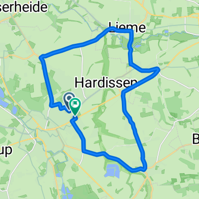
MTB Teutoburgerwald
A cycling route starting in Lage, North Rhine-Westphalia, Germany.
Overview
About this route
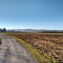
Challenging MTB route with many climbs up to 12%. From B66 Bielefeld towards Lage, turn right in Kachtenhausen onto Hellweg. After about 3 kilometers, you reach the starting point, the former inn 'Lippische Rose'. Crossing Hellweg towards Stapelage, after about 250 meters, turn left onto an agricultural path that leads to 'Hörster Egge'. At the Egge, turn left and ride through the forest until you reach a pasture fence. Here, take a sharp right towards Hörste Mittelpunkt. Continue towards 'Haus des Gastes' and the swimming pool. By Freibadstrasse, you access the Trimmpfad, which turns right at the upper end. Passing the Bienenschmidt forest inn, continue along the Senneland landscape on the Sennerandweg to Augustdorf -Panzerringstrasse and bridge-. Here, turn left towards Dörenschlucht. Passing the gravel plant, the second entrance on the left goes up the so-called Eh-Berg. At the top, there are 6 forks. The second from the left is towards Mordkuhle. Here, through the parking lot, take a right onto the road and after 200 meters, left into the forest towards Teutoburgerwald-Sender. The path leads directly to the transmitter -climb-. Passing the transmitter and barrier towards Oesterholz. Here too, continue along the Senne. After a few kilometers, turn left towards Heiligenkirchen. At the end of the path, turn right. Then, continue on an asphalt path (turn left) towards Hangstein. (Inn)
- -:--
- Duration
- 40.5 km
- Distance
- 614 m
- Ascent
- 614 m
- Descent
- ---
- Avg. speed
- ---
- Max. altitude
Route quality
Waytypes & surfaces along the route
Waytypes
Track
19.4 km
(48 %)
Quiet road
8.5 km
(21 %)
Surfaces
Paved
17 km
(42 %)
Unpaved
20.6 km
(51 %)
Asphalt
16.6 km
(41 %)
Gravel
15.4 km
(38 %)
Route highlights
Points of interest along the route
Point of interest after 0.6 km
Links abbiegen auf einen landwirtschaftlichen Weg. Leichte Steigung

Point of interest after 0.6 km

Point of interest after 0.7 km
Point of interest after 1 km
Oben auf der Kuppe nach links durch den Wald fahren bis zu einem Weidezaun, dort rechts abbiegen

Point of interest after 1.3 km

Point of interest after 2.3 km

Point of interest after 2.7 km

Point of interest after 3.4 km

Point of interest after 3.8 km
Den Trimmfahrt in Hörste bis zum Hermannsweg hoch, dann rechts abbiegen in Richtung Bienenschmidt

Point of interest after 5.2 km
Gaststätte Bienenschmidt

Point of interest after 5.7 km

Point of interest after 8.1 km

Point of interest after 10.4 km
Point of interest after 12.1 km
Rechts einbiegen bis zum Schotterwerk fahren. Hier die zweite Abfahrt nach links benutzen, sogenannter Ehbergweg.

Point of interest after 12.4 km
Am Schotterwerk ist nach Feierabend die Schranke geschlossen. Links vorbeifahren, dann den zweiten Weg links einbiegen zum Ehberg

Point of interest after 13.7 km
Auf der Spitze des Ehberg gehen fünf Waldwege (nicht ausgezeichnet) ab. Auf dem Forto rechts den hinteren Weg nutzen in Richtung Mordkuhle.
Point of interest after 14.9 km
Achtung hier muss die Lopshorner Alle überquert werden.
Point of interest after 17.7 km
Rundfunksender Teutoburgerwald
Point of interest after 24.3 km
Hier rechts abbiegen
Continue with Bikemap
Use, edit, or download this cycling route
You would like to ride MTB Teutoburgerwald or customize it for your own trip? Here is what you can do with this Bikemap route:
Free features
- Save this route as favorite or in collections
- Copy & plan your own version of this route
- Sync your route with Garmin or Wahoo
Premium features
Free trial for 3 days, or one-time payment. More about Bikemap Premium.
- Navigate this route on iOS & Android
- Export a GPX / KML file of this route
- Create your custom printout (try it for free)
- Download this route for offline navigation
Discover more Premium features.
Get Bikemap PremiumFrom our community
Other popular routes starting in Lage
 Segelflugplatz und Wasserpark
- Distance
- 44 km
- Ascent
- 271 m
- Descent
- 270 m
- Location
- Lage, North Rhine-Westphalia, Germany
 Freiligrathstraße, Lage nach Freiligrathstraße, Lage
- Distance
- 24 km
- Ascent
- 155 m
- Descent
- 155 m
- Location
- Lage, North Rhine-Westphalia, Germany
 Sonntagmorgen Rundtour zum Skypoint Detmold und zurück.
- Distance
- 25.8 km
- Ascent
- 114 m
- Descent
- 113 m
- Location
- Lage, North Rhine-Westphalia, Germany
 Freiligrathstraße, Lage nach Freiligrathstraße, Lage
- Distance
- 17 km
- Ascent
- 115 m
- Descent
- 114 m
- Location
- Lage, North Rhine-Westphalia, Germany
 Lage Hörste Herrmann bikemap
- Distance
- 39.3 km
- Ascent
- 646 m
- Descent
- 529 m
- Location
- Lage, North Rhine-Westphalia, Germany
 Sportlich-Sehenswert
- Distance
- 125.8 km
- Ascent
- 779 m
- Descent
- 777 m
- Location
- Lage, North Rhine-Westphalia, Germany
- Wappenweg Lage
- Distance
- 46.2 km
- Ascent
- 585 m
- Descent
- 590 m
- Location
- Lage, North Rhine-Westphalia, Germany
 MTB Teutoburgerwald
- Distance
- 40.5 km
- Ascent
- 614 m
- Descent
- 614 m
- Location
- Lage, North Rhine-Westphalia, Germany
Open it in the app