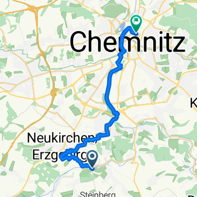
Chemnitz - Südböhmen - Südmähren
A cycling route starting in Neukirchen, Saxony, Germany.
Overview
About this route
Czech Republic is beautiful! The more the route leads southeast, starting from Tábor, the more cyclists there are. The signage is very good.
Food and drink: very good. There is no shortage of 'cykloterasa'.
The old town centers are charming.
- -:--
- Duration
- 844.3 km
- Distance
- 2,001 m
- Ascent
- 2,130 m
- Descent
- ---
- Avg. speed
- ---
- Max. altitude
Route quality
Waytypes & surfaces along the route
Waytypes
Road
270.2 km
(32 %)
Track
160.4 km
(19 %)
Surfaces
Paved
413.7 km
(49 %)
Unpaved
84.4 km
(10 %)
Asphalt
388.4 km
(46 %)
Ground
33.8 km
(4 %)
Route highlights
Points of interest along the route

Photo after 40.6 km
Karlsroute
Point of interest after 47.9 km
1. Tag 52 km (Tacho)
Point of interest after 102.6 km
2. Tag 63 km (Tacho) Camping Březová
Point of interest after 143 km
3. Tag 36 km (Tacho) PenzionNad Hradbami
Point of interest after 202.5 km
Eisenbahnmuseum der ČD
Point of interest after 220.1 km
4. Tag 84 km (Tacho) Hotel Roztoky
Point of interest after 289 km
5. Tag 70 km (Tacho) Camping Cholin
Point of interest after 345.9 km
6. Tag und 7.Tag 61 km (Tacho) Hotel Grand Tabor
Point of interest after 402.6 km
8. Tag 83 km (Tacho) Camping Třebon

Photo after 458.6 km
Fahrt mit der Schmalspurbahn Jindřichohradecké Úzkokolejky JHMD von Nova Byštrice nach Jindřichův Hradec (Neuhaus)
Point of interest after 479.3 km
9. Tag und 10. Tag 51 km (Tacho) Penzion Eva
Point of interest after 539.1 km
11. Tag 64 km (Tacho)
Point of interest after 604.8 km
12. Tag 67 km (Tacho) Camping Vranov
Point of interest after 656.8 km
13. Tag 58 km (Tacho) penzion Podzámči
Point of interest after 744.3 km
Fahrt mit der Eisenbahn nach Břeclav und zurück: Internationale Eisenbahn-Fahrkarten gibts nur an größeren Bahnhöfen.

Photo after 836.5 km
14. - 18. Tag: Penzion Bařina Dolni Dunajovice 14. Tag: 60 km (Tacho) 15. Tag: 37 km (Tacho) Mikulov - Valtice 16. Tag: 60 km (Tacho) Mikulov - Březí - Úvaly -.Valtice - Lednice 17. Tag: 24 km (Tacho) Mikulov 18. Tag:Heimreise mit dem Zug ab Mikulov
Continue with Bikemap
Use, edit, or download this cycling route
You would like to ride Chemnitz - Südböhmen - Südmähren or customize it for your own trip? Here is what you can do with this Bikemap route:
Free features
- Save this route as favorite or in collections
- Copy & plan your own version of this route
- Split it into stages to create a multi-day tour
- Sync your route with Garmin or Wahoo
Premium features
Free trial for 3 days, or one-time payment. More about Bikemap Premium.
- Navigate this route on iOS & Android
- Export a GPX / KML file of this route
- Create your custom printout (try it for free)
- Download this route for offline navigation
Discover more Premium features.
Get Bikemap PremiumFrom our community
Other popular routes starting in Neukirchen
Eisenweg und Pfarrhübel über Eisnsiedel- Distance
- 35.4 km
- Ascent
- 574 m
- Descent
- 572 m
- Location
- Neukirchen, Saxony, Germany
Chemnitz-Keilberg-Fichtelberg-Chemnitz- Distance
- 119.9 km
- Ascent
- 1,362 m
- Descent
- 1,362 m
- Location
- Neukirchen, Saxony, Germany
Adelsbergturm- Distance
- 31.2 km
- Ascent
- 418 m
- Descent
- 430 m
- Location
- Neukirchen, Saxony, Germany
Wasserschloßweg, Chemnitz nach An der Markthalle, Chemnitz- Distance
- 19 km
- Ascent
- 244 m
- Descent
- 282 m
- Location
- Neukirchen, Saxony, Germany
Wasserschloßweg nach Chemnitz Kulturhauptstadt Europa 2025- Distance
- 30.7 km
- Ascent
- 423 m
- Descent
- 423 m
- Location
- Neukirchen, Saxony, Germany
Eisenweg und Pfarrhübel ohne Einsiedel- Distance
- 34.5 km
- Ascent
- 488 m
- Descent
- 485 m
- Location
- Neukirchen, Saxony, Germany
Neukirchen - Lugau - Neukirchen- Distance
- 28.1 km
- Ascent
- 197 m
- Descent
- 193 m
- Location
- Neukirchen, Saxony, Germany
Erzgebirgstour- Distance
- 96.5 km
- Ascent
- 1,517 m
- Descent
- 1,494 m
- Location
- Neukirchen, Saxony, Germany
Open it in the app

