

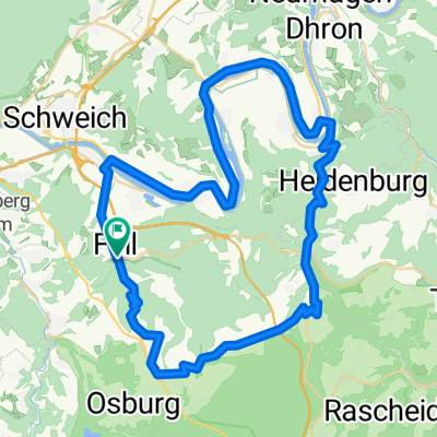
Rundweg Fell_Riol_Mehring_Thörnich_Leiwen(Schwimmbad)_Zummet_Büdlicher-Brück_Fell
A cycling route starting in Fell, Rhineland-Palatinate, Germany.
Overview
About this route
Rundweg von Fell nach Riol, dann an der Mosel entlang nach Mehring, andere Moselseite bis nach Thörnich, dort wieder über die Mosel an Köwerich vorbei nach Leiwen, hoch zum Panoramabad, direkt unterhalb vom Bad vorbei der Straße folgen nach Zummet, dann durch Dhrontal nach Büdlicher Brück, jetzt Berg hoch über den Mehringer Berg zurück nach Fell.
- -:--
- Duration
- 39.8 km
- Distance
- 569 m
- Ascent
- 564 m
- Descent
- ---
- Avg. speed
- ---
- Avg. speed
Continue with Bikemap
Use, edit, or download this cycling route
You would like to ride Rundweg Fell_Riol_Mehring_Thörnich_Leiwen(Schwimmbad)_Zummet_Büdlicher-Brück_Fell or customize it for your own trip? Here is what you can do with this Bikemap route:
Free features
- Save this route as favorite or in collections
- Copy & plan your own version of this route
- Sync your route with Garmin or Wahoo
Premium features
Free trial for 3 days, or one-time payment. More about Bikemap Premium.
- Navigate this route on iOS & Android
- Export a GPX / KML file of this route
- Create your custom printout (try it for free)
- Download this route for offline navigation
Discover more Premium features.
Get Bikemap PremiumFrom our community
Other popular routes starting in Fell
 02 Tag Fell 2 Braunenerg
- Distance
- 44.9 km
- Ascent
- 425 m
- Descent
- 476 m
- Location
- Fell, Rhineland-Palatinate, Germany
 Saisonstart 2011 - RTF des RV Schwalbe Trier 1932 e.V. - 49 km Strecke
- Distance
- 42.7 km
- Ascent
- 242 m
- Descent
- 244 m
- Location
- Fell, Rhineland-Palatinate, Germany
 20 Stunden Fell
- Distance
- 17 km
- Ascent
- 360 m
- Descent
- 361 m
- Location
- Fell, Rhineland-Palatinate, Germany
 Saisonstart 2011 - RTF des RV Schwalbe Trier 1932 e.V. - 71 km Strecke
- Distance
- 70 km
- Ascent
- 515 m
- Descent
- 515 m
- Location
- Fell, Rhineland-Palatinate, Germany
 Fell ILLU Tour
- Distance
- 50.8 km
- Ascent
- 572 m
- Descent
- 564 m
- Location
- Fell, Rhineland-Palatinate, Germany
 Rundweg Fell_Riol_Mehring_Thörnich_Leiwen(Schwimmbad)_Zummet_Büdlicher-Brück_Fell
- Distance
- 39.8 km
- Ascent
- 569 m
- Descent
- 564 m
- Location
- Fell, Rhineland-Palatinate, Germany
 Waldracher Straße 18, Fell nach Graf-Siegfried-Straße 32, Saarburg
- Distance
- 41.4 km
- Ascent
- 466 m
- Descent
- 506 m
- Location
- Fell, Rhineland-Palatinate, Germany
 Fell - Thomm
- Distance
- 5.3 km
- Ascent
- 342 m
- Descent
- 69 m
- Location
- Fell, Rhineland-Palatinate, Germany
Open it in the app