
Saisonstart 2011 - RTF des RV Schwalbe Trier 1932 e.V. - 49 km Strecke
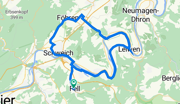
A cycling route starting in Fell, Rhineland-Palatinate, Germany.
Overview
About this route
Saisonstart 2011 - 49 km
geführte RTF (G) des RV Schwalbe Trier 1932 e.V.
Alle weiteren Hinweise zu dieser Strecke -> hier anklicken
- -:--
- Duration
- 42.7 km
- Distance
- 242 m
- Ascent
- 244 m
- Descent
- ---
- Avg. speed
- ---
- Avg. speed

Route quality
Waytypes & surfaces along the route
Waytypes
Busy road
18.1 km
(42 %)
Path
8.7 km
(20 %)
Surfaces
Paved
38.8 km
(91 %)
Unpaved
0.4 km
(<1 %)
Asphalt
36.5 km
(85 %)
Paved (undefined)
1.9 km
(4 %)
Route highlights
Points of interest along the route
Point of interest after 26.1 km
Kontrolle <b>Leiwen</b> am Dorfplatz
Continue with Bikemap
Use, edit, or download this cycling route
You would like to ride Saisonstart 2011 - RTF des RV Schwalbe Trier 1932 e.V. - 49 km Strecke or customize it for your own trip? Here is what you can do with this Bikemap route:
Free features
- Save this route as favorite or in collections
- Copy & plan your own version of this route
- Sync your route with Garmin or Wahoo
Premium features
Free trial for 3 days, or one-time payment. More about Bikemap Premium.
- Navigate this route on iOS & Android
- Export a GPX / KML file of this route
- Create your custom printout (try it for free)
- Download this route for offline navigation
Discover more Premium features.
Get Bikemap PremiumFrom our community
Other popular routes starting in Fell
 Saisonstart 2011 - RTF des RV Schwalbe Trier 1932 e.V. - 49 km Strecke
- Distance
- 42.7 km
- Ascent
- 242 m
- Descent
- 244 m
- Location
- Fell, Rhineland-Palatinate, Germany
 Saisonstart 2011 - RTF des RV Schwalbe Trier 1932 e.V. - 71 km Strecke
- Distance
- 70 km
- Ascent
- 515 m
- Descent
- 515 m
- Location
- Fell, Rhineland-Palatinate, Germany
 02 Tag Fell 2 Braunenerg
- Distance
- 44.9 km
- Ascent
- 425 m
- Descent
- 476 m
- Location
- Fell, Rhineland-Palatinate, Germany
 20 Stunden Fell
- Distance
- 17 km
- Ascent
- 360 m
- Descent
- 361 m
- Location
- Fell, Rhineland-Palatinate, Germany
 Rundweg Fell_Riol_Mehring_Thörnich_Leiwen(Schwimmbad)_Zummet_Büdlicher-Brück_Fell
- Distance
- 39.8 km
- Ascent
- 569 m
- Descent
- 564 m
- Location
- Fell, Rhineland-Palatinate, Germany
 Waldracher Straße 18, Fell nach Graf-Siegfried-Straße 32, Saarburg
- Distance
- 41.4 km
- Ascent
- 466 m
- Descent
- 506 m
- Location
- Fell, Rhineland-Palatinate, Germany
 Feller Feierabendrunde
- Distance
- 10.8 km
- Ascent
- 96 m
- Descent
- 131 m
- Location
- Fell, Rhineland-Palatinate, Germany
 Fell - Thomm
- Distance
- 5.3 km
- Ascent
- 342 m
- Descent
- 69 m
- Location
- Fell, Rhineland-Palatinate, Germany
Open it in the app