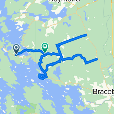
Muskoka Recreational route #2
A cycling route starting in Bracebridge, Ontario, Canada.
Overview
About this route
Longer Recreational route ideal for road and hybrid bicycles. hybrid tires are recommended for the dirt/gravel section of South Monck Dr. which offers beautiful tree cover. One steep hill located on Santa's Village road but otherwise relatively easier rolling terrain. Riders can also choose to ride the bike path along Muskoka Rd#4 instead of following the higher traffic main rd.
- -:--
- Duration
- 28.2 km
- Distance
- 216 m
- Ascent
- 207 m
- Descent
- ---
- Avg. speed
- 314 m
- Max. altitude
Route quality
Waytypes & surfaces along the route
Waytypes
Quiet road
13.3 km
(47 %)
Road
10.7 km
(38 %)
Surfaces
Paved
15.8 km
(56 %)
Unpaved
2.8 km
(10 %)
Asphalt
12.1 km
(43 %)
Paved (undefined)
3.7 km
(13 %)
Route highlights
Points of interest along the route
Point of interest after 0 km
Remedy Bike/Muskoka Outfitters Start here with free parking and great service from local cyclists. Route maps available here. www.remedybike.ca
Continue with Bikemap
Use, edit, or download this cycling route
You would like to ride Muskoka Recreational route #2 or customize it for your own trip? Here is what you can do with this Bikemap route:
Free features
- Save this route as favorite or in collections
- Copy & plan your own version of this route
- Sync your route with Garmin or Wahoo
Premium features
Free trial for 3 days, or one-time payment. More about Bikemap Premium.
- Navigate this route on iOS & Android
- Export a GPX / KML file of this route
- Create your custom printout (try it for free)
- Download this route for offline navigation
Discover more Premium features.
Get Bikemap PremiumFrom our community
Other popular routes starting in Bracebridge
- Housey's Rapids Loop
- Distance
- 63.7 km
- Ascent
- 317 m
- Descent
- 300 m
- Location
- Bracebridge, Ontario, Canada
- Bracebridge no. 2 (Milford Bay Route)
- Distance
- 68.4 km
- Ascent
- 692 m
- Descent
- 690 m
- Location
- Bracebridge, Ontario, Canada
- Muskoka 3
- Distance
- 35.9 km
- Ascent
- 212 m
- Descent
- 214 m
- Location
- Bracebridge, Ontario, Canada
- Nice rolling hill 100km
- Distance
- 83.7 km
- Ascent
- 602 m
- Descent
- 610 m
- Location
- Bracebridge, Ontario, Canada
- For Nina
- Distance
- 62.8 km
- Ascent
- 733 m
- Descent
- 714 m
- Location
- Bracebridge, Ontario, Canada
- Gravenhurst Beach Road loop (popular)
- Distance
- 56.8 km
- Ascent
- 407 m
- Descent
- 389 m
- Location
- Bracebridge, Ontario, Canada
- Muskoka Hilly 100km
- Distance
- 81.3 km
- Ascent
- 694 m
- Descent
- 650 m
- Location
- Bracebridge, Ontario, Canada
- Muskoka Recreational route #2
- Distance
- 28.2 km
- Ascent
- 216 m
- Descent
- 207 m
- Location
- Bracebridge, Ontario, Canada
Open it in the app