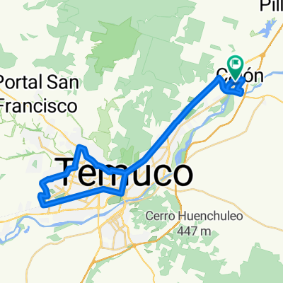
Pumalal - Monteverde 40K
A cycling route starting in Temuco, Regi贸n de la Araucan铆a, Chile.
Overview
About this route
Pumalal - Monteverde 40K
(cloned from route 3148411)
- -:--
- Duration
- 37.4 km
- Distance
- 795 m
- Ascent
- 795 m
- Descent
- ---
- Avg. speed
- ---
- Avg. speed
Route quality
Waytypes & surfaces along the route
Waytypes
Undefined
37.4 km
(100 %)
Surfaces
Undefined
37.4 km
(100 %)
Continue with Bikemap
Use, edit, or download this cycling route
You would like to ride Pumalal - Monteverde 40K or customize it for your own trip? Here is what you can do with this Bikemap route:
Free features
- Save this route as favorite or in collections
- Copy & plan your own version of this route
- Sync your route with Garmin or Wahoo
Premium features
Free trial for 3 days, or one-time payment. More about Bikemap Premium.
- Navigate this route on iOS & Android
- Export a GPX / KML file of this route
- Create your custom printout (try it for free)
- Download this route for offline navigation
Discover more Premium features.
Get Bikemap PremiumFrom our community
Other popular routes starting in Temuco
- Pumalal - Rucamanke 40K
- Distance
- 38.7 km
- Ascent
- 736 m
- Descent
- 739 m
- Location
- Temuco, Regi贸n de la Araucan铆a, Chile
- De 3 Norte / Los Avellanos, Temuco a Los Chilcos / Los Avellanos - Sur, Temuco
- Distance
- 5.6 km
- Ascent
- 31 m
- Descent
- 31 m
- Location
- Temuco, Regi贸n de la Araucan铆a, Chile
- Outdoor Sportlife Temuco - Tra帽i Tra帽i
- Distance
- 20.5 km
- Ascent
- 156 m
- Descent
- 157 m
- Location
- Temuco, Regi贸n de la Araucan铆a, Chile
- Ruta vuelta r铆o caut铆n, puente entre rios
- Distance
- 41.4 km
- Ascent
- 187 m
- Descent
- 182 m
- Location
- Temuco, Regi贸n de la Araucan铆a, Chile
- El 脕lamo Express
- Distance
- 30.8 km
- Ascent
- 144 m
- Descent
- 145 m
- Location
- Temuco, Regi贸n de la Araucan铆a, Chile
- Vuelta al Cerro Mariposa
- Distance
- 25.5 km
- Ascent
- 239 m
- Descent
- 241 m
- Location
- Temuco, Regi贸n de la Araucan铆a, Chile
- Outdoor Sportlife Temuco - Parapente con Chorip谩n
- Distance
- 19.6 km
- Ascent
- 315 m
- Descent
- 310 m
- Location
- Temuco, Regi贸n de la Araucan铆a, Chile
- 3 Cerros
- Distance
- 67.2 km
- Ascent
- 1,369 m
- Descent
- 1,366 m
- Location
- Temuco, Regi贸n de la Araucan铆a, Chile