

ironkidz_201510_微風車訓_FINAL
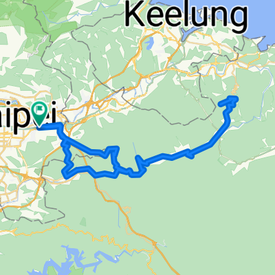
A cycling route starting in Taipei, Taipei, Taiwan.
Overview
About this route
edited at 20151021
(cloned from route 3302018) (cloned from route 3308743) (cloned from route 3309726)- -:--
- Duration
- 40.1 km
- Distance
- 73 m
- Ascent
- 73 m
- Descent
- ---
- Avg. speed
- ---
- Max. altitude
Route quality
Waytypes & surfaces along the route
Waytypes
Cycleway
31.3 km
(78 %)
Pedestrian area
5.6 km
(14 %)
Surfaces
Paved
30.5 km
(76 %)
Asphalt
28.9 km
(72 %)
Concrete
1.6 km
(4 %)
Undefined
9.6 km
(24 %)
Route highlights
Points of interest along the route
Bike service after 17.4 km
補給停車處

Drinking water after 17.6 km
補給休息站
Continue with Bikemap
Use, edit, or download this cycling route
You would like to ride ironkidz_201510_微風車訓_FINAL or customize it for your own trip? Here is what you can do with this Bikemap route:
Free features
- Save this route as favorite or in collections
- Copy & plan your own version of this route
- Sync your route with Garmin or Wahoo
Premium features
Free trial for 3 days, or one-time payment. More about Bikemap Premium.
- Navigate this route on iOS & Android
- Export a GPX / KML file of this route
- Create your custom printout (try it for free)
- Download this route for offline navigation
Discover more Premium features.
Get Bikemap PremiumFrom our community
Other popular routes starting in Taipei
 信義河濱-故宮-平等里-冷水坑-二子坪-八拉卡-紅樹林-河濱-公館(O型)
- Distance
- 84.1 km
- Ascent
- 1,319 m
- Descent
- 1,338 m
- Location
- Taipei, Taipei, Taiwan
 信義-崇德街-阿柔洋-碎心坡-草湳-貓空站-政大-萬芳社區-信義(O型)
- Distance
- 35.5 km
- Ascent
- 1,399 m
- Descent
- 1,376 m
- Location
- Taipei, Taipei, Taiwan
 永和-淡水來回
- Distance
- 71.1 km
- Ascent
- 90 m
- Descent
- 81 m
- Location
- Taipei, Taipei, Taiwan
 中社爬坡路徑
- Distance
- 4.3 km
- Ascent
- 294 m
- Descent
- 54 m
- Location
- Taipei, Taipei, Taiwan
 腳踏車環島 2011/01/20~2011/01/31
- Distance
- 1,239.7 km
- Ascent
- 1,590 m
- Descent
- 1,590 m
- Location
- Taipei, Taipei, Taiwan
 2010/11/02 南港昆陽站到五分山折返 練習路線圖
- Distance
- 87.1 km
- Ascent
- 1,374 m
- Descent
- 1,374 m
- Location
- Taipei, Taipei, Taiwan
 20081011 北海岸1
- Distance
- 80.8 km
- Ascent
- 392 m
- Descent
- 383 m
- Location
- Taipei, Taipei, Taiwan
 三橫一豎+花東海岸線
- Distance
- 1,118.3 km
- Ascent
- 8,871 m
- Descent
- 8,871 m
- Location
- Taipei, Taipei, Taiwan
Open it in the app