
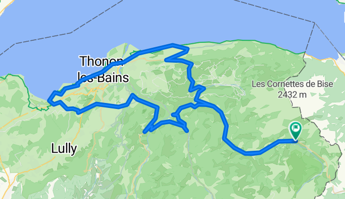
Alpentour '98/Etappe 3: LaChapelle - Vinzier - Evian - Thonon - Armoy - LaChapelle
A cycling route starting in Châtel, Auvergne-Rhône-Alpes, France.
Overview
About this route
zum GenferSee
- -:--
- Duration
- 106.9 km
- Distance
- 1,173 m
- Ascent
- 1,170 m
- Descent
- ---
- Avg. speed
- ---
- Max. altitude

Route quality
Waytypes & surfaces along the route
Waytypes
Road
25.7 km
(24 %)
Quiet road
16 km
(15 %)
Surfaces
Paved
84.5 km
(79 %)
Unpaved
1.1 km
(1 %)
Asphalt
84.5 km
(79 %)
Gravel
1.1 km
(1 %)
Undefined
21.4 km
(20 %)
Continue with Bikemap
Use, edit, or download this cycling route
You would like to ride Alpentour '98/Etappe 3: LaChapelle - Vinzier - Evian - Thonon - Armoy - LaChapelle or customize it for your own trip? Here is what you can do with this Bikemap route:
Free features
- Save this route as favorite or in collections
- Copy & plan your own version of this route
- Split it into stages to create a multi-day tour
- Sync your route with Garmin or Wahoo
Premium features
Free trial for 3 days, or one-time payment. More about Bikemap Premium.
- Navigate this route on iOS & Android
- Export a GPX / KML file of this route
- Create your custom printout (try it for free)
- Download this route for offline navigation
Discover more Premium features.
Get Bikemap PremiumFrom our community
Other popular routes starting in Châtel
 Abondance 100km mit See
- Distance
- 104.4 km
- Ascent
- 1,119 m
- Descent
- 1,119 m
- Location
- Châtel, Auvergne-Rhône-Alpes, France
 odcinek 1: La Chapelle-Bulle-Marly
- Distance
- 136.7 km
- Ascent
- 1,143 m
- Descent
- 1,529 m
- Location
- Châtel, Auvergne-Rhône-Alpes, France
 wypad wloski cz.1
- Distance
- 94.4 km
- Ascent
- 2,483 m
- Descent
- 1,054 m
- Location
- Châtel, Auvergne-Rhône-Alpes, France
 Chatel Gravel
- Distance
- 64.9 km
- Ascent
- 1,713 m
- Descent
- 1,713 m
- Location
- Châtel, Auvergne-Rhône-Alpes, France
 Alpentour '98/Etappe 3: LaChapelle - Vinzier - Evian - Thonon - Armoy - LaChapelle
- Distance
- 106.9 km
- Ascent
- 1,173 m
- Descent
- 1,170 m
- Location
- Châtel, Auvergne-Rhône-Alpes, France
 La Chapelle-dÀbondance - Genf
- Distance
- 82.2 km
- Ascent
- 460 m
- Descent
- 1,122 m
- Location
- Châtel, Auvergne-Rhône-Alpes, France
 Abondance, Corbier, Joux Plane, Ramaz, Jambaz
- Distance
- 160.2 km
- Ascent
- 3,220 m
- Descent
- 3,220 m
- Location
- Châtel, Auvergne-Rhône-Alpes, France
 Alpentour '98/Etappe 5: LaChapelle - Corbier - Joux Verte/Avoriaz - Corbier - LaChapelle
- Distance
- 92.9 km
- Ascent
- 2,089 m
- Descent
- 2,088 m
- Location
- Châtel, Auvergne-Rhône-Alpes, France
Open it in the app