

VVDrawskie-2
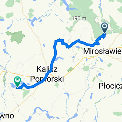
A cycling route starting in Mirosławiec, West Pomeranian Voivodeship, Poland.
Overview
About this route
Orle - Mirosławiec - Wąsosz - Czaplinek
- -:--
- Duration
- 52.3 km
- Distance
- 188 m
- Ascent
- 189 m
- Descent
- ---
- Avg. speed
- ---
- Max. altitude
Continue with Bikemap
Use, edit, or download this cycling route
You would like to ride VVDrawskie-2 or customize it for your own trip? Here is what you can do with this Bikemap route:
Free features
- Save this route as favorite or in collections
- Copy & plan your own version of this route
- Sync your route with Garmin or Wahoo
Premium features
Free trial for 3 days, or one-time payment. More about Bikemap Premium.
- Navigate this route on iOS & Android
- Export a GPX / KML file of this route
- Create your custom printout (try it for free)
- Download this route for offline navigation
Discover more Premium features.
Get Bikemap PremiumFrom our community
Other popular routes starting in Mirosławiec
 Kalisz
- Distance
- 32.7 km
- Ascent
- 809 m
- Descent
- 874 m
- Location
- Mirosławiec, West Pomeranian Voivodeship, Poland
 29B, Stara Korytnica do 29B, Stara Korytnica
- Distance
- 19.3 km
- Ascent
- 142 m
- Descent
- 145 m
- Location
- Mirosławiec, West Pomeranian Voivodeship, Poland
 Drawskie 2
- Distance
- 56.6 km
- Ascent
- 212 m
- Descent
- 207 m
- Location
- Mirosławiec, West Pomeranian Voivodeship, Poland
 Drzewoszewo
- Distance
- 451.4 km
- Ascent
- 459 m
- Descent
- 283 m
- Location
- Mirosławiec, West Pomeranian Voivodeship, Poland
 24k - Tour de 12 Baza Lotnicza w Mirosławcu
- Distance
- 24 km
- Ascent
- 120 m
- Descent
- 120 m
- Location
- Mirosławiec, West Pomeranian Voivodeship, Poland
 BBGT_2
- Distance
- 275.3 km
- Ascent
- 1,049 m
- Descent
- 1,087 m
- Location
- Mirosławiec, West Pomeranian Voivodeship, Poland
 Mirosławiec - Płytnica
- Distance
- 73 km
- Ascent
- 235 m
- Descent
- 263 m
- Location
- Mirosławiec, West Pomeranian Voivodeship, Poland
 Z 7Ogrodów do Starej Korytnicy i z powrotem
- Distance
- 15.2 km
- Ascent
- 134 m
- Descent
- 134 m
- Location
- Mirosławiec, West Pomeranian Voivodeship, Poland
Open it in the app