

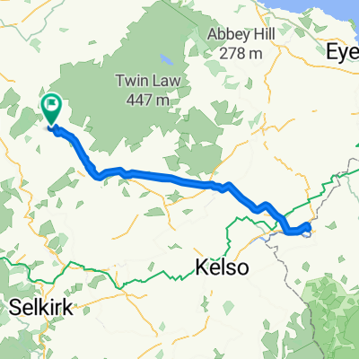
Southern Upland heading east towards Longformacus
A cycling route starting in Lauder, Scotland, United Kingdom.
Overview
About this route
A mix of quiet roads and tracks out of Oxton, then once on the Southern Uplance Way it goes from grassy field to boggy heather, to rocky sheep paths..nut not before you climb many miles. Hard going- but lots of wildlife from lack of humans..a truly special and remote walk on this section..amazing views looking across to the Eildons..let alone the vaxt Lammermuirs that it skirts.
- -:--
- Duration
- 89.1 km
- Distance
- 894 m
- Ascent
- 845 m
- Descent
- ---
- Avg. speed
- ---
- Max. altitude

Continue with Bikemap
Use, edit, or download this cycling route
You would like to ride Southern Upland heading east towards Longformacus or customize it for your own trip? Here is what you can do with this Bikemap route:
Free features
- Save this route as favorite or in collections
- Copy & plan your own version of this route
- Split it into stages to create a multi-day tour
- Sync your route with Garmin or Wahoo
Premium features
Free trial for 3 days, or one-time payment. More about Bikemap Premium.
- Navigate this route on iOS & Android
- Export a GPX / KML file of this route
- Create your custom printout (try it for free)
- Download this route for offline navigation
Discover more Premium features.
Get Bikemap PremiumFrom our community
Other popular routes starting in Lauder
 Local Sutra Loop
- Distance
- 23.9 km
- Ascent
- 439 m
- Descent
- 443 m
- Location
- Lauder, Scotland, United Kingdom
 Oxton to Prestonpans challenge. Dropped off in Oxton- then back roads to Gifford then on to East Saulton via railway and then through Dalkeith Manor, River Esk
- Distance
- 82 km
- Ascent
- 534 m
- Descent
- 757 m
- Location
- Lauder, Scotland, United Kingdom
 Hills with Eddy en Route..
- Distance
- 99.9 km
- Ascent
- 753 m
- Descent
- 654 m
- Location
- Lauder, Scotland, United Kingdom
 Southern Upland heading east towards Longformacus
- Distance
- 89.1 km
- Ascent
- 894 m
- Descent
- 845 m
- Location
- Lauder, Scotland, United Kingdom
 Newcastel-or- BUST !
- Distance
- 302.2 km
- Ascent
- 1,272 m
- Descent
- 1,273 m
- Location
- Lauder, Scotland, United Kingdom
 I hour Ride 2/24/15
- Distance
- 38.3 km
- Ascent
- 179 m
- Descent
- 333 m
- Location
- Lauder, Scotland, United Kingdom
 April Inners loop
- Distance
- 88.6 km
- Ascent
- 707 m
- Descent
- 708 m
- Location
- Lauder, Scotland, United Kingdom
 To England and Back to Oxton. Scotland
- Distance
- 93.7 km
- Ascent
- 459 m
- Descent
- 454 m
- Location
- Lauder, Scotland, United Kingdom
Open it in the app