
20160312_024655.gpx
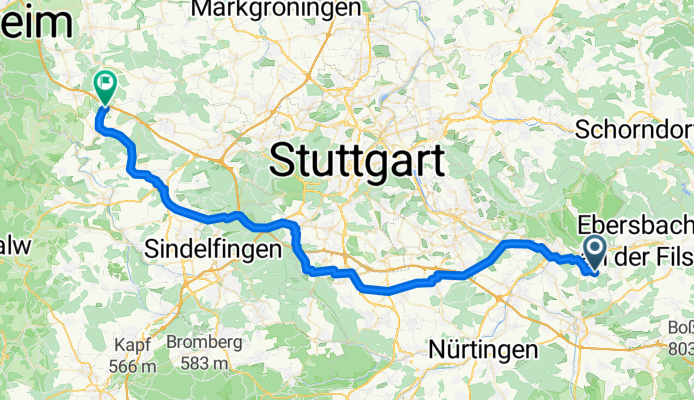
A cycling route starting in Hochdorf, Baden-Wurttemberg, Germany.
Overview
About this route
TEASI track
- -:--
- Duration
- 63.5 km
- Distance
- 490 m
- Ascent
- 347 m
- Descent
- ---
- Avg. speed
- ---
- Max. altitude
Route quality
Waytypes & surfaces along the route
Waytypes
Path
11.4 km
(18 %)
Quiet road
10.8 km
(17 %)
Surfaces
Paved
55.9 km
(88 %)
Unpaved
3.8 km
(6 %)
Asphalt
54 km
(85 %)
Paved (undefined)
1.9 km
(3 %)
Route highlights
Points of interest along the route
Point of interest after 0 km
Steinbeisstraße, 4
Point of interest after 13.1 km
N48°41.939' E9°20.292'
Point of interest after 32.3 km
N48°41.539' E9°07.739'
Point of interest after 63.5 km
Alemannenstraße, 6
Continue with Bikemap
Use, edit, or download this cycling route
You would like to ride 20160312_024655.gpx or customize it for your own trip? Here is what you can do with this Bikemap route:
Free features
- Save this route as favorite or in collections
- Copy & plan your own version of this route
- Sync your route with Garmin or Wahoo
Premium features
Free trial for 3 days, or one-time payment. More about Bikemap Premium.
- Navigate this route on iOS & Android
- Export a GPX / KML file of this route
- Create your custom printout (try it for free)
- Download this route for offline navigation
Discover more Premium features.
Get Bikemap PremiumFrom our community
Other popular routes starting in Hochdorf
 Rundtour-Hochdorf-Plochingen-Wernau Wendlingen-Kirchheim-Ohmden-Schlierbach-Ebersbach/Fils-Weiler-Roßwälden-Hochdorf
- Distance
- 49.2 km
- Ascent
- 359 m
- Descent
- 359 m
- Location
- Hochdorf, Baden-Wurttemberg, Germany
 edeka
edeka- Distance
- 8.1 km
- Ascent
- 174 m
- Descent
- 167 m
- Location
- Hochdorf, Baden-Wurttemberg, Germany
 edeka
edeka- Distance
- 3.9 km
- Ascent
- 69 m
- Descent
- 65 m
- Location
- Hochdorf, Baden-Wurttemberg, Germany
 Kleine Albtour
- Distance
- 65.9 km
- Ascent
- 1,078 m
- Descent
- 1,004 m
- Location
- Hochdorf, Baden-Wurttemberg, Germany
 Gehrnwald Trail
- Distance
- 0.5 km
- Ascent
- 0 m
- Descent
- 34 m
- Location
- Hochdorf, Baden-Wurttemberg, Germany
 20160312_024655.gpx
- Distance
- 63.5 km
- Ascent
- 490 m
- Descent
- 347 m
- Location
- Hochdorf, Baden-Wurttemberg, Germany
 Deutschland Süd Nord
- Distance
- 957.2 km
- Ascent
- 519 m
- Descent
- 808 m
- Location
- Hochdorf, Baden-Wurttemberg, Germany
 Zum Schwäbischen Meer
- Distance
- 147 km
- Ascent
- 1,826 m
- Descent
- 1,594 m
- Location
- Hochdorf, Baden-Wurttemberg, Germany
Open it in the app