

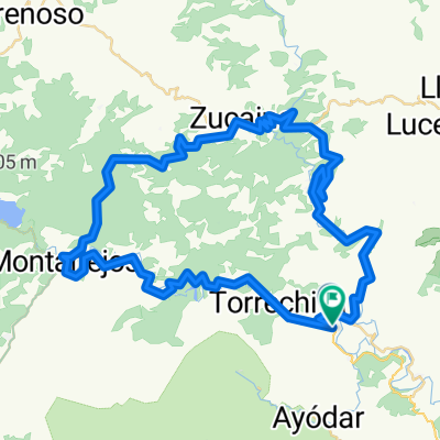
Toga-Argelita-Lucena-Zucaina-Montanejos-Toga
A cycling route starting in Toga, Valencia, Spain.
Overview
About this route
Stages that reach around 2000 meters of cumulative altitude deserve a certain respect. In this case, the biggest challenge is at the start, at the Mas del Moro pass, which, although not excessively tough, is appreciated to do it early and fresh. There are two classic leg-breaker sections and two more passes that are manageable and without any difficulty.
- -:--
- Duration
- 97 km
- Distance
- 3,698 m
- Ascent
- 3,679 m
- Descent
- ---
- Avg. speed
- 986 m
- Max. altitude
Route quality
Waytypes & surfaces along the route
Waytypes
Road
26.2 km
(27 %)
Quiet road
4.8 km
(5 %)
Surfaces
Paved
39.8 km
(41 %)
Asphalt
38.8 km
(40 %)
Concrete
1 km
(1 %)
Undefined
57.2 km
(59 %)
Continue with Bikemap
Use, edit, or download this cycling route
You would like to ride Toga-Argelita-Lucena-Zucaina-Montanejos-Toga or customize it for your own trip? Here is what you can do with this Bikemap route:
Free features
- Save this route as favorite or in collections
- Copy & plan your own version of this route
- Split it into stages to create a multi-day tour
- Sync your route with Garmin or Wahoo
Premium features
Free trial for 3 days, or one-time payment. More about Bikemap Premium.
- Navigate this route on iOS & Android
- Export a GPX / KML file of this route
- Create your custom printout (try it for free)
- Download this route for offline navigation
Discover more Premium features.
Get Bikemap PremiumFrom our community
Other popular routes starting in Toga
 Argelita
- Distance
- 83 km
- Ascent
- 1,133 m
- Descent
- 1,136 m
- Location
- Toga, Valencia, Spain
 Toga-Argelita-Lucena-Zucaina-Montanejos-Toga
- Distance
- 97 km
- Ascent
- 3,698 m
- Descent
- 3,679 m
- Location
- Toga, Valencia, Spain
 toga barracas toga
- Distance
- 106.6 km
- Ascent
- 1,083 m
- Descent
- 1,083 m
- Location
- Toga, Valencia, Spain
 toga-castillo-zucaina-montanejos-toga
- Distance
- 70.9 km
- Ascent
- 995 m
- Descent
- 999 m
- Location
- Toga, Valencia, Spain
 toga-cortes-olba-toga
- Distance
- 105.8 km
- Ascent
- 1,342 m
- Descent
- 1,342 m
- Location
- Toga, Valencia, Spain
 MAS DEL MORO-REMOLCADOR
- Distance
- 73 km
- Ascent
- 1,303 m
- Descent
- 1,302 m
- Location
- Toga, Valencia, Spain
 Toga-Barracas
- Distance
- 106.7 km
- Ascent
- 1,072 m
- Descent
- 1,081 m
- Location
- Toga, Valencia, Spain
 toga ludiente zucaina montañeros toga
- Distance
- 71.2 km
- Ascent
- 1,016 m
- Descent
- 1,008 m
- Location
- Toga, Valencia, Spain
Open it in the app