

krátký okruh: Myslejovice - Žarovice - Drahany - Myslejovice
A cycling route starting in Otaslavice, Olomoucký kraj, Czechia.
Overview
About this route
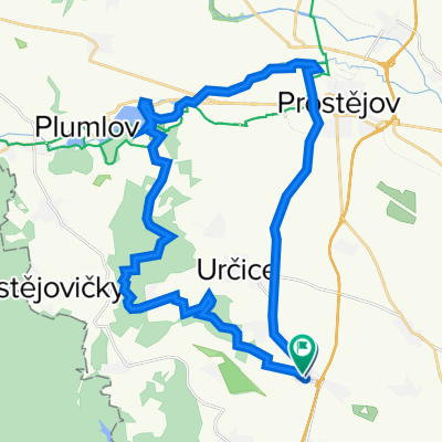
This is a relatively short 35 km circuit. From Myslejovice to Žarovice, the route is mostly flat except for a few short ascents and descents. We reach Křenůvky via a state road. Just after entering Křenůvky, at the first intersection, we turn left, pass the cultural house and sports field, then turn left again, ascending a short climb above Křenůvky. We pass signs indicating a prohibition on entering the military area (this is the absolute edge of the military area, which is completely safe, and the chance of encountering military police is almost nil). We continue straight along the asphalt road until we arrive at Prostějovičky, which we ascend via short hairpin bends. We pass by an inn, descend into the village, where at the main intersection we turn left. We ride alongside ponds on a newly surfaced asphalt road to the end of the village. Here the asphalt ends and is followed by a one-kilometer forest path section. We reach the Osina forest nursery, where we encounter asphalt again. We turn left and after about 100 meters turn right onto a lovely asphalt road. This leads us into the forest until we reach the ponds. We pass them and follow the stream flowing out of the ponds until we come to Žarovice. I describe the route in detail because I consider it very favorable for cyclists due to the lack of automotive traffic and the beautiful landscape it passes through. It is thus a kind of advantageous alternative to the state road Myslejovice - Krumsín - Soběsuky. From Žarovice, the route proceeds up the well-known Drahanský hill along road no. 377 all the way to Drahan. Here we take the newly opened cycle path to Nové Sady. Before Nové Sady, this route turns into the interior of the military area. Since it is already inside the military area without any marking, I will not go into detail. The road here runs on somewhat broken asphalt and near the end on a new surface, in case anyone is interested in the surface and wants to explore here on their own. Except for the long Drahanský hill, it is an easy route suitable for a morning or afternoon ride through the forests of the Drahanská Highlands.
- -:--
- Duration
- 34.2 km
- Distance
- 548 m
- Ascent
- 548 m
- Descent
- ---
- Avg. speed
- ---
- Max. altitude
Continue with Bikemap
Use, edit, or download this cycling route
You would like to ride krátký okruh: Myslejovice - Žarovice - Drahany - Myslejovice or customize it for your own trip? Here is what you can do with this Bikemap route:
Free features
- Save this route as favorite or in collections
- Copy & plan your own version of this route
- Sync your route with Garmin or Wahoo
Premium features
Free trial for 3 days, or one-time payment. More about Bikemap Premium.
- Navigate this route on iOS & Android
- Export a GPX / KML file of this route
- Create your custom printout (try it for free)
- Download this route for offline navigation
Discover more Premium features.
Get Bikemap PremiumFrom our community
Other popular routes starting in Otaslavice
 Vranovice-kolem VP-Vranovice
- Distance
- 71 km
- Ascent
- 814 m
- Descent
- 814 m
- Location
- Otaslavice, Olomoucký kraj, Czechia
 krátký okruh: Myslejovice - Žarovice - Drahany - Myslejovice
- Distance
- 34.2 km
- Ascent
- 548 m
- Descent
- 548 m
- Location
- Otaslavice, Olomoucký kraj, Czechia
 Myslejovice-Jedovnice-Rudice-Adamov-Křtiny-Ruprechtov-Pustiměř-Brodek u Prostějova-Určice-Myslejovice
- Distance
- 120.4 km
- Ascent
- 2,097 m
- Descent
- 2,139 m
- Location
- Otaslavice, Olomoucký kraj, Czechia
 Výlet do Modré
- Distance
- 113.8 km
- Ascent
- 1,283 m
- Descent
- 1,362 m
- Location
- Otaslavice, Olomoucký kraj, Czechia
 Vranovická
- Distance
- 29.2 km
- Ascent
- 363 m
- Descent
- 356 m
- Location
- Otaslavice, Olomoucký kraj, Czechia
 Do práce a z práce...
- Distance
- 31.6 km
- Ascent
- 346 m
- Descent
- 342 m
- Location
- Otaslavice, Olomoucký kraj, Czechia
 Smržické vandr (CT 110 km) 2011
- Distance
- 135.1 km
- Ascent
- 0 m
- Descent
- 0 m
- Location
- Otaslavice, Olomoucký kraj, Czechia
 Myslejovice-Podivice-Pustiměř-Ivanovice-Vrchoslavice-Klenovice-Prostějov-Myslejovice
- Distance
- 70.4 km
- Ascent
- 595 m
- Descent
- 577 m
- Location
- Otaslavice, Olomoucký kraj, Czechia
Open it in the app