

Moritzberg and...
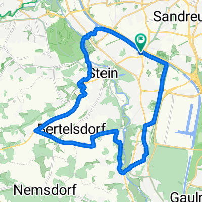
A cycling route starting in Stein, Bavaria, Germany.
Overview
About this route
fain de la Ungelstetten pin padure pe langa rau
- -:--
- Duration
- 106.9 km
- Distance
- 424 m
- Ascent
- 394 m
- Descent
- ---
- Avg. speed
- ---
- Max. altitude
Continue with Bikemap
Use, edit, or download this cycling route
You would like to ride Moritzberg and... or customize it for your own trip? Here is what you can do with this Bikemap route:
Free features
- Save this route as favorite or in collections
- Copy & plan your own version of this route
- Split it into stages to create a multi-day tour
- Sync your route with Garmin or Wahoo
Premium features
Free trial for 3 days, or one-time payment. More about Bikemap Premium.
- Navigate this route on iOS & Android
- Export a GPX / KML file of this route
- Create your custom printout (try it for free)
- Download this route for offline navigation
Discover more Premium features.
Get Bikemap PremiumFrom our community
Other popular routes starting in Stein
 Vom Haui nach Hause oder von zu Hause zum Haui
- Distance
- 14.8 km
- Ascent
- 64 m
- Descent
- 56 m
- Location
- Stein, Bavaria, Germany
 Am Alten Kanal von Nbg bis Neumarkt id OPf. und zurück
- Distance
- 78.8 km
- Ascent
- 421 m
- Descent
- 390 m
- Location
- Stein, Bavaria, Germany
 Stein Rohr Roßtal
- Distance
- 39.7 km
- Ascent
- 279 m
- Descent
- 279 m
- Location
- Stein, Bavaria, Germany
 NBG Hafen_Berching alter und neuer Kanal
- Distance
- 116.6 km
- Ascent
- 375 m
- Descent
- 351 m
- Location
- Stein, Bavaria, Germany
 Panoramatour mit Pepp
- Distance
- 23 km
- Ascent
- 177 m
- Descent
- 177 m
- Location
- Stein, Bavaria, Germany
 Tour mit Jan
- Distance
- 68.5 km
- Ascent
- 367 m
- Descent
- 369 m
- Location
- Stein, Bavaria, Germany
 Rund um Röthenbach und Stein
- Distance
- 21.5 km
- Ascent
- 141 m
- Descent
- 141 m
- Location
- Stein, Bavaria, Germany
 Stations-Tour 2021
- Distance
- 44.7 km
- Ascent
- 270 m
- Descent
- 265 m
- Location
- Stein, Bavaria, Germany
Open it in the app