

RSG - Rund im Odenwald 2008
A cycling route starting in Erbach im Odenwald, Hesse, Germany.
Overview
About this route
0
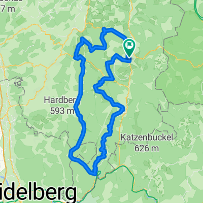
Start: Erbach Ivory Museum
Destination: Erbach Bullau
Barometric altitude measurement:
Polar S720i = 1946 HM
Garmin Edge 705 = 2016 HM
Route:
Polar S720i = 114.5 km
Garmin Edge 705 = 114.18 km
- -:--
- Duration
- 113 km
- Distance
- 2,007 m
- Ascent
- 1,866 m
- Descent
- ---
- Avg. speed
- 522 m
- Max. altitude
vorbelastung
created this 18 years ago
Route quality
Waytypes & surfaces along the route
Waytypes
Road
32.8 km
29 %
Track
7.9 km
7 %
Surfaces
Paved
68.9 km
(61 %)
Unpaved
4.5 km
(4 %)
Asphalt
57.6 km
51 %
Paved (undefined)
11.3 km
10 %
Continue with Bikemap
Use, edit, or download this cycling route
You would like to ride RSG - Rund im Odenwald 2008 or customize it for your own trip? Here is what you can do with this Bikemap route:
Free features
- Save this route as favorite or in collections
- Copy & plan your own version of this route
- Split it into stages to create a multi-day tour
- Sync your route with Garmin or Wahoo
Premium features
Free trial for 3 days, or one-time payment. More about Bikemap Premium.
- Navigate this route on iOS & Android
- Export a GPX / KML file of this route
- Create your custom printout (try it for free)
- Download this route for offline navigation
Discover more Premium features.
Get Bikemap PremiumFrom our community
Other popular routes starting in Erbach im Odenwald
- Werner-von-Siemens-Straße, Erbach nach Martin-Luther-Straße, Erbach0
- 0.5 km
- 20 m
- 3 m
- Erbach im Odenwald, Hesse, Germany


Open it in the app