Alpentocht 2015 dag 2 Definitief
- 97 km
- 2,122 m
- 1,224 m
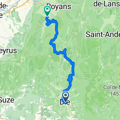
- Die, Auvergne-Rhône-Alpes, France
A cycling route starting in Die, Auvergne-Rhône-Alpes, France.
Overview
Not really to "die", but to "Die", the nearby town. This was a short shopping trip, but the scenery is excellent and the traffic wasn't bad. A majority of D93 also has decent road shoulder.
This is really beautiful countryside where we're staying for a week.
created this 9 years ago
Route quality
Road
6.3 km
(18 %)
Quiet road
4.9 km
(14 %)
Paved
24.1 km
(69 %)
Unpaved
0.7 km
(2 %)
Asphalt
24.1 km
(69 %)
Unpaved (undefined)
0.7 km
(2 %)
Undefined
10.1 km
(29 %)
Continue with Bikemap
You would like to ride 2016 Ride Day 87 - Jansac Circle to Die or customize it for your own trip? Here is what you can do with this Bikemap route:
Free trial for 3 days, or one-time payment. More about Bikemap Premium.
Discover more Premium features.
Get Bikemap PremiumFrom our community
Open it in the app