

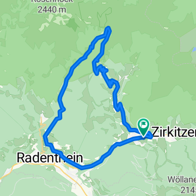
Patergassen - Nockalmstraße - Turrach - St.Lorenzen - Patergassen
A cycling route starting in Kleinkirchheim, Carinthia, Austria.
Overview
About this route
Schöne, aber anstrengende Tagestour. Die erste Kilometer geht es zum Aufwärmen auf der B95 von Patergassen nach Ebene Reichenau, vor der Teufelsbrücke biegt man auf die Nockalmstraße, die für Fahrräder mautfrei ist, ab. Kurz vor der Prieshütte verlässt man die Nockalmsstraße - hier endet die Asphaltstrecke - auf einen Güterweg ein. Ein nicht allzu schwerer Anstieg führt zur Pregartscharte, dort geht es rechts weg auf einem Wanderweg, der aber mit dem MTB gut zu befahren ist, nördlich des Rinsennocks über die Winkler Alm auf die Turracher Höhe. Ein paar hundert Meter zum Ausrasten kann man die B95 nutzen, bevor es nach dem Hochschober wieder auf einem Schotterweg über den Grünsee nach Saureggen geht. Zuerst über einen Waldweg und dann auf einer Schotterstraße gelangt man nach St.Lorenzen. Von jetzt geht es bergab auf der Landesstraße L66 durch den Schußgraben nach Ebene Reichenau, nach Patergassen kann man die letzten Kilometer auf der B95 genießen.
- -:--
- Duration
- 50.2 km
- Distance
- 1,171 m
- Ascent
- 1,171 m
- Descent
- ---
- Avg. speed
- ---
- Max. altitude
Route quality
Waytypes & surfaces along the route
Waytypes
Track
14.1 km
(28 %)
Road
10.9 km
(22 %)
Surfaces
Paved
21.7 km
(43 %)
Unpaved
11.3 km
(22 %)
Asphalt
20.8 km
(41 %)
Gravel
9.7 km
(19 %)
Continue with Bikemap
Use, edit, or download this cycling route
You would like to ride Patergassen - Nockalmstraße - Turrach - St.Lorenzen - Patergassen or customize it for your own trip? Here is what you can do with this Bikemap route:
Free features
- Save this route as favorite or in collections
- Copy & plan your own version of this route
- Sync your route with Garmin or Wahoo
Premium features
Free trial for 3 days, or one-time payment. More about Bikemap Premium.
- Navigate this route on iOS & Android
- Export a GPX / KML file of this route
- Create your custom printout (try it for free)
- Download this route for offline navigation
Discover more Premium features.
Get Bikemap PremiumFrom our community
Other popular routes starting in Kleinkirchheim
 Rund-um-den-Kolmnock
- Distance
- 23.7 km
- Ascent
- 1,032 m
- Descent
- 1,032 m
- Location
- Kleinkirchheim, Carinthia, Austria
 Über St. Oswald und die Totelitzen auf die Fronalm
- Distance
- 16.1 km
- Ascent
- 1,166 m
- Descent
- 1,168 m
- Location
- Kleinkirchheim, Carinthia, Austria
 Gurkursprung-Tour
- Distance
- 27.8 km
- Ascent
- 1,030 m
- Descent
- 1,030 m
- Location
- Kleinkirchheim, Carinthia, Austria
 Bad Kleinkirchheim Runde
- Distance
- 34.4 km
- Ascent
- 1,126 m
- Descent
- 1,148 m
- Location
- Kleinkirchheim, Carinthia, Austria
 Genußrunde BKK
- Distance
- 28.7 km
- Ascent
- 1,986 m
- Descent
- 1,980 m
- Location
- Kleinkirchheim, Carinthia, Austria
 Nockalmstrasse
- Distance
- 33.1 km
- Ascent
- 1,396 m
- Descent
- 1,043 m
- Location
- Kleinkirchheim, Carinthia, Austria
 14 st oswald
- Distance
- 32.1 km
- Ascent
- 1,068 m
- Descent
- 1,067 m
- Location
- Kleinkirchheim, Carinthia, Austria
 R3 ab Hotel 54km Osten-Süden 608HM
- Distance
- 55.3 km
- Ascent
- 741 m
- Descent
- 743 m
- Location
- Kleinkirchheim, Carinthia, Austria
Open it in the app