
Fitnes Route-1
A cycling route starting in Oersdorf, Schleswig-Holstein, Germany.
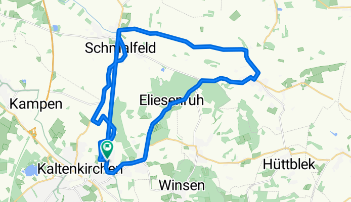
Overview
About this route
vom Erlenweg zum Erlenweg über Schmalfeld und Struvenhütten
- -:--
- Duration
- 31 km
- Distance
- 85 m
- Ascent
- 85 m
- Descent
- ---
- Avg. speed
- ---
- Max. altitude
Route quality
Waytypes & surfaces along the route
Waytypes
Quiet road
15.2 km
(49 %)
Path
5.9 km
(19 %)
Surfaces
Paved
28.3 km
(91 %)
Unpaved
1.2 km
(4 %)
Asphalt
27.3 km
(88 %)
Paved (undefined)
0.9 km
(3 %)
Continue with Bikemap
Use, edit, or download this cycling route
You would like to ride Fitnes Route-1 or customize it for your own trip? Here is what you can do with this Bikemap route:
Free features
- Save this route as favorite or in collections
- Copy & plan your own version of this route
- Sync your route with Garmin or Wahoo
Premium features
Free trial for 3 days, or one-time payment. More about Bikemap Premium.
- Navigate this route on iOS & Android
- Export a GPX / KML file of this route
- Create your custom printout (try it for free)
- Download this route for offline navigation
Discover more Premium features.
Get Bikemap PremiumFrom our community
Other popular routes starting in Oersdorf
 Oersdorf to Ploen
- Distance
- 62.2 km
- Ascent
- 193 m
- Descent
- 189 m
- Location
- Oersdorf, Schleswig-Holstein, Germany
 Kisdorfer Weg 8, Kaltenkirchen nach Ulzburger Straße 476A, Norderstedt
- Distance
- 17.6 km
- Ascent
- 46 m
- Descent
- 40 m
- Location
- Oersdorf, Schleswig-Holstein, Germany
 Radrunde durch Kaltenkirchen
- Distance
- 24.9 km
- Ascent
- 114 m
- Descent
- 116 m
- Location
- Oersdorf, Schleswig-Holstein, Germany
 Quick bike tour from Kaltenkirchen to Hamburg
- Distance
- 32.4 km
- Ascent
- 102 m
- Descent
- 112 m
- Location
- Oersdorf, Schleswig-Holstein, Germany
 Kaki-Durch die Alsterwiesen
- Distance
- 29.9 km
- Ascent
- 89 m
- Descent
- 89 m
- Location
- Oersdorf, Schleswig-Holstein, Germany
 Oersdorf bis Hamburg Hafeninsel
- Distance
- 39.9 km
- Ascent
- 44 m
- Descent
- 71 m
- Location
- Oersdorf, Schleswig-Holstein, Germany
 Kisdorfer Weg 3B, Kaltenkirchen nach Kisdorfer Weg 3C, Kaltenkirchen
- Distance
- 9 km
- Ascent
- 33 m
- Descent
- 32 m
- Location
- Oersdorf, Schleswig-Holstein, Germany
 Feldstraße 11, Kaltenkirchen nach Grünberger Straße 19A, Henstedt-Ulzburg
- Distance
- 17.7 km
- Ascent
- 0 m
- Descent
- 11 m
- Location
- Oersdorf, Schleswig-Holstein, Germany
Open it in the app