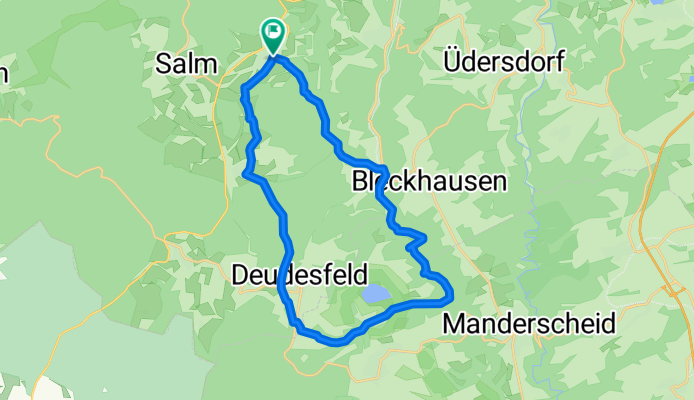
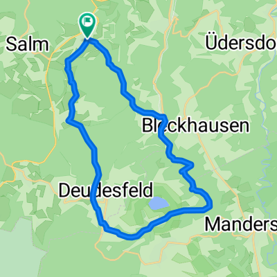
- 22.1 km
- 385 m
- 362 m
- Wallenborn, Rhineland-Palatinate, Germany
Hinterbüschrunde
A cycling route starting in Wallenborn, Rhineland-Palatinate, Germany.
Overview
About this route
Beautiful circular route mainly leading over field paths. Partly asphalted, partly gravel, partly forest trail. Rest opportunities along the route, and a swim at Meerfelder Maar is also possible. Only one steeper climb of about 2 km. Route is well suited for a family outing. A load-capable bicycle is recommended.
- -:--
- Duration
- 22.1 km
- Distance
- 385 m
- Ascent
- 362 m
- Descent
- ---
- Avg. speed
- 527 m
- Max. altitude
Route quality
Waytypes & surfaces along the route
Waytypes
Track
13.5 km
61 %
Road
4.2 km
19 %
Surfaces
Paved
11.7 km
(53 %)
Unpaved
5.3 km
(24 %)
Asphalt
8.8 km
40 %
Paved (undefined)
2.9 km
13 %
Route highlights
Points of interest along the route
Point of interest after 6.3 km
Bleckhausener Mühle; schöner Platz für eine kurze Rast, und um ein kühles Radler zu trinken
Point of interest after 11.4 km
Meerfelder Maar; hier kann bei passendem Wetter eine Schwimpause eingelegt werden
Continue with Bikemap
Use, edit, or download this cycling route
You would like to ride Hinterbüschrunde or customize it for your own trip? Here is what you can do with this Bikemap route:
Free features
- Save this route as favorite or in collections
- Copy & plan your own version of this route
- Sync your route with Garmin or Wahoo
Premium features
Free trial for 3 days, or one-time payment. More about Bikemap Premium.
- Navigate this route on iOS & Android
- Export a GPX / KML file of this route
- Create your custom printout (try it for free)
- Download this route for offline navigation
Discover more Premium features.
Get Bikemap PremiumFrom our community
Other popular routes starting in Wallenborn
- Hinterbüschrunde
- Alans route along the Moselstrasse CLONED FROM ROUTE 1248013
- 143.8 km
- 1,178 m
- 1,168 m
- Wallenborn, Rhineland-Palatinate, Germany
- zur Meerfelder Maar
- 12.3 km
- 192 m
- 254 m
- Wallenborn, Rhineland-Palatinate, Germany
- 4D2.17-5 Wallenborn HotViller
- 185.3 km
- 1,517 m
- 1,597 m
- Wallenborn, Rhineland-Palatinate, Germany
- Von Wallenborn bis Daun
- 12.6 km
- 302 m
- 293 m
- Wallenborn, Rhineland-Palatinate, Germany
Open it in the app


