2016 Ride Day 104 - Valence Semi-Circle to Bourg-de-Péage (Romans-sur-Isère)
A cycling route starting in Saint-Marcel-lès-Valence, Auvergne-Rhône-Alpes, France.
Overview
About this route
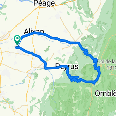
This was a very circuitous route to get to a store to keep us from starving. Except for the roads within Bourg-de-Péage, all were excellent low traffic roads.
- -:--
- Duration
- 58.9 km
- Distance
- 471 m
- Ascent
- 469 m
- Descent
- ---
- Avg. speed
- ---
- Avg. speed
Route photos
Route quality
Waytypes & surfaces along the route
Waytypes
Road
30.5 km
(52 %)
Quiet road
13.2 km
(22 %)
Surfaces
Paved
27.4 km
(47 %)
Unpaved
0.1 km
(<1 %)
Asphalt
27.4 km
(47 %)
Loose gravel
0.1 km
(<1 %)
Continue with Bikemap
Use, edit, or download this cycling route
You would like to ride 2016 Ride Day 104 - Valence Semi-Circle to Bourg-de-Péage (Romans-sur-Isère) or customize it for your own trip? Here is what you can do with this Bikemap route:
Free features
- Save this route as favorite or in collections
- Copy & plan your own version of this route
- Sync your route with Garmin or Wahoo
Premium features
Free trial for 3 days, or one-time payment. More about Bikemap Premium.
- Navigate this route on iOS & Android
- Export a GPX / KML file of this route
- Create your custom printout (try it for free)
- Download this route for offline navigation
Discover more Premium features.
Get Bikemap PremiumFrom our community
Other popular routes starting in Saint-Marcel-lès-Valence
- Valence TGV - Bessette
- Distance
- 150.6 km
- Ascent
- 1,726 m
- Descent
- 875 m
- Location
- Saint-Marcel-lès-Valence, Auvergne-Rhône-Alpes, France
- 2016 Ride Day 92 - Valence to Le-Puy-en-Velay
- Distance
- 138.1 km
- Ascent
- 1,767 m
- Descent
- 1,285 m
- Location
- Saint-Marcel-lès-Valence, Auvergne-Rhône-Alpes, France
- 13946585-RDS Global 2022
- Distance
- 838 km
- Ascent
- 22,985 m
- Descent
- 22,660 m
- Location
- Saint-Marcel-lès-Valence, Auvergne-Rhône-Alpes, France
- Lyon (train to) - Avignon - Saint Tropez - Cannes - Nice - Monte Carlo
- Distance
- 543.1 km
- Ascent
- 1,398 m
- Descent
- 1,561 m
- Location
- Saint-Marcel-lès-Valence, Auvergne-Rhône-Alpes, France
- 2016 Ride Day 90 - Valence Circle to Col de Tourniol
- Distance
- 67.2 km
- Ascent
- 1,178 m
- Descent
- 1,176 m
- Location
- Saint-Marcel-lès-Valence, Auvergne-Rhône-Alpes, France
- 2016 Ride Day 91 - Valence Circle to Col de Rotisson
- Distance
- 77 km
- Ascent
- 484 m
- Descent
- 482 m
- Location
- Saint-Marcel-lès-Valence, Auvergne-Rhône-Alpes, France
- 2016 Ride Day 106 - Valence to St-Sauveur-de-Montagut
- Distance
- 76.4 km
- Ascent
- 413 m
- Descent
- 369 m
- Location
- Saint-Marcel-lès-Valence, Auvergne-Rhône-Alpes, France
- Valence Tgv / Garel
- Distance
- 51.7 km
- Ascent
- 354 m
- Descent
- 274 m
- Location
- Saint-Marcel-lès-Valence, Auvergne-Rhône-Alpes, France
Open it in the app