

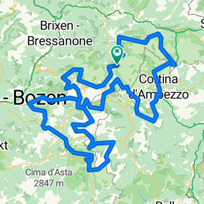
Dolomites +
A cycling route starting in Abtei-Badia, Trentino-Alto Adige, Italy.
Overview
About this route
We are going for distance, we are going for speed (and therefore use lifts)
Day 1 0-45=45km, Day 2 45-115=70km, Day 3 115-155=40km
Day 4 155-215=60km, Day 5 215-265=50km, Day 6 265-325=60km
- -:--
- Duration
- 380.4 km
- Distance
- 11,658 m
- Ascent
- 11,668 m
- Descent
- ---
- Avg. speed
- ---
- Max. altitude
Route highlights
Points of interest along the route
Point of interest after 19.5 km
Point of interest after 52.1 km
Point of interest after 54 km
Point of interest after 133.4 km
Point of interest after 134.3 km
Point of interest after 178.9 km
Point of interest after 251.7 km
Point of interest after 311.2 km
Point of interest after 315 km
Point of interest after 326.6 km
Point of interest after 361.7 km
Point of interest after 376.6 km
Pension La Muda: lamuda.it
Continue with Bikemap
Use, edit, or download this cycling route
You would like to ride Dolomites + or customize it for your own trip? Here is what you can do with this Bikemap route:
Free features
- Save this route as favorite or in collections
- Copy & plan your own version of this route
- Split it into stages to create a multi-day tour
- Sync your route with Garmin or Wahoo
Premium features
Free trial for 3 days, or one-time payment. More about Bikemap Premium.
- Navigate this route on iOS & Android
- Export a GPX / KML file of this route
- Create your custom printout (try it for free)
- Download this route for offline navigation
Discover more Premium features.
Get Bikemap PremiumFrom our community
Other popular routes starting in Abtei-Badia
 La Villa - Pian dell'Armentara
- Distance
- 20.6 km
- Ascent
- 862 m
- Descent
- 860 m
- Location
- Abtei-Badia, Trentino-Alto Adige, Italy
 Maratona dles Dolomites
- Distance
- 137.5 km
- Ascent
- 3,883 m
- Descent
- 3,539 m
- Location
- Abtei-Badia, Trentino-Alto Adige, Italy
 hotel-linder-neu-groeden-pralongia-hochplateau - proposed
- Distance
- 45.5 km
- Ascent
- 2,099 m
- Descent
- 2,099 m
- Location
- Abtei-Badia, Trentino-Alto Adige, Italy
 Dolomites +
- Distance
- 380.4 km
- Ascent
- 11,658 m
- Descent
- 11,668 m
- Location
- Abtei-Badia, Trentino-Alto Adige, Italy
 Kirche San Leonardo - Kirche Heilig Kreuz
- Distance
- 15.8 km
- Ascent
- 933 m
- Descent
- 933 m
- Location
- Abtei-Badia, Trentino-Alto Adige, Italy
 Medalges
- Distance
- 51.8 km
- Ascent
- 2,005 m
- Descent
- 2,003 m
- Location
- Abtei-Badia, Trentino-Alto Adige, Italy
 St. Kassian-Armentarola-Störes-Corvara-St. Kassian
- Distance
- 23.2 km
- Ascent
- 822 m
- Descent
- 827 m
- Location
- Abtei-Badia, Trentino-Alto Adige, Italy
 Campolongo_Pellegrino_Valles_2015_2
- Distance
- 104.3 km
- Ascent
- 2,326 m
- Descent
- 2,684 m
- Location
- Abtei-Badia, Trentino-Alto Adige, Italy
Open it in the app