

Nonantola to Peschiera del garda
A cycling route starting in Nonantola, Emilia-Romagna, Italy.
Overview
About this route
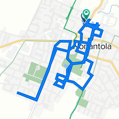
From Via Oppio Nonantola to Hotel Bel Sito
- -:--
- Duration
- 116.1 km
- Distance
- 105 m
- Ascent
- 58 m
- Descent
- ---
- Avg. speed
- ---
- Max. altitude

Route quality
Waytypes & surfaces along the route
Waytypes
Road
26.7 km
(23 %)
Quiet road
20.9 km
(18 %)
Surfaces
Paved
47.6 km
(41 %)
Unpaved
27.9 km
(24 %)
Asphalt
43 km
(37 %)
Ground
9.3 km
(8 %)
Continue with Bikemap
Use, edit, or download this cycling route
You would like to ride Nonantola to Peschiera del garda or customize it for your own trip? Here is what you can do with this Bikemap route:
Free features
- Save this route as favorite or in collections
- Copy & plan your own version of this route
- Split it into stages to create a multi-day tour
- Sync your route with Garmin or Wahoo
Premium features
Free trial for 3 days, or one-time payment. More about Bikemap Premium.
- Navigate this route on iOS & Android
- Export a GPX / KML file of this route
- Create your custom printout (try it for free)
- Download this route for offline navigation
Discover more Premium features.
Get Bikemap PremiumFrom our community
Other popular routes starting in Nonantola
 Nonantola to Peschiera del garda
- Distance
- 116.1 km
- Ascent
- 105 m
- Descent
- 58 m
- Location
- Nonantola, Emilia-Romagna, Italy
 giro semplice top
- Distance
- 20.6 km
- Ascent
- 18 m
- Descent
- 20 m
- Location
- Nonantola, Emilia-Romagna, Italy
 Da Via Walter Tabacchi 47, Nonantola a Via Walter Tabacchi 57, Nonantola
- Distance
- 10.8 km
- Ascent
- 103 m
- Descent
- 101 m
- Location
- Nonantola, Emilia-Romagna, Italy
 sgaetanotop 2
- Distance
- 33 km
- Ascent
- 39 m
- Descent
- 39 m
- Location
- Nonantola, Emilia-Romagna, Italy
 Giro a velocità lenta in Campazzo
- Distance
- 9.2 km
- Ascent
- 10 m
- Descent
- 16 m
- Location
- Nonantola, Emilia-Romagna, Italy
 Da Via Piave 14, Nonantola a Via 11 Settembre 28, Lama di Reno
- Distance
- 52.6 km
- Ascent
- 223 m
- Descent
- 140 m
- Location
- Nonantola, Emilia-Romagna, Italy
 BO_XXX_Nonantola_Castelmaggiore.gpx
- Distance
- 44.7 km
- Ascent
- 26 m
- Descent
- 26 m
- Location
- Nonantola, Emilia-Romagna, Italy
 Nonantola - San Cesario - Piumazzo - Samoggia - Oasi di Manzolino - Nonantola
- Distance
- 51 km
- Ascent
- 39 m
- Descent
- 38 m
- Location
- Nonantola, Emilia-Romagna, Italy
Open it in the app