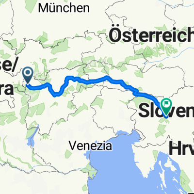
Preko tri drzave s autom
A cycling route starting in Glurns, Trentino-Alto Adige, Italy.
Overview
About this route
- -:--
- Duration
- 133.4 km
- Distance
- 1,813 m
- Ascent
- 1,808 m
- Descent
- ---
- Avg. speed
- ---
- Avg. speed
Route quality
Waytypes & surfaces along the route
Waytypes
Busy road
111 km
(83 %)
Quiet road
8.1 km
(6 %)
Surfaces
Paved
95.4 km
(71 %)
Unpaved
4.4 km
(3 %)
Asphalt
94.7 km
(71 %)
Ground
2.1 km
(2 %)
Continue with Bikemap
Use, edit, or download this cycling route
You would like to ride Preko tri drzave s autom or customize it for your own trip? Here is what you can do with this Bikemap route:
Free features
- Save this route as favorite or in collections
- Copy & plan your own version of this route
- Sync your route with Garmin or Wahoo
Premium features
Free trial for 3 days, or one-time payment. More about Bikemap Premium.
- Navigate this route on iOS & Android
- Export a GPX / KML file of this route
- Create your custom printout (try it for free)
- Download this route for offline navigation
Discover more Premium features.
Get Bikemap PremiumFrom our community
Other popular routes starting in Glurns
- Preko tri drzave s autom
- Distance
- 133.4 km
- Ascent
- 1,813 m
- Descent
- 1,808 m
- Location
- Glurns, Trentino-Alto Adige, Italy
- 🚴♀️E*Bike🇮🇩+🇨🇭 Glurns-STILFSER-JOCH-Glurns
- Distance
- 66 km
- Ascent
- 1,844 m
- Descent
- 1,841 m
- Location
- Glurns, Trentino-Alto Adige, Italy
- Glurns - Madritschjoch - Latsch.
- Distance
- 66 km
- Ascent
- 2,236 m
- Descent
- 2,530 m
- Location
- Glurns, Trentino-Alto Adige, Italy
- Stilfserjoch
- Distance
- 65 km
- Ascent
- 1,856 m
- Descent
- 1,856 m
- Location
- Glurns, Trentino-Alto Adige, Italy
- OrtlerRunde
- Distance
- 314.8 km
- Ascent
- 9,655 m
- Descent
- 9,655 m
- Location
- Glurns, Trentino-Alto Adige, Italy
- Wiesenweg nach Glurns
- Distance
- 12.5 km
- Ascent
- 1,244 m
- Descent
- 172 m
- Location
- Glurns, Trentino-Alto Adige, Italy
- Dol Stilfser Joch
- Distance
- 62 km
- Ascent
- 1,836 m
- Descent
- 1,836 m
- Location
- Glurns, Trentino-Alto Adige, Italy
- GDS - BDS: 05 Glurns - Nauders (15 Schlinigpass, Uina-Schlucht xxxxx)
- Distance
- 56.3 km
- Ascent
- 1,829 m
- Descent
- 1,386 m
- Location
- Glurns, Trentino-Alto Adige, Italy
Open it in the app