

Overview
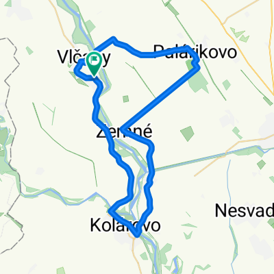
About this route
- -:--
- Duration
- 23 km
- Distance
- 13 m
- Ascent
- 12 m
- Descent
- ---
- Avg. speed
- ---
- Max. altitude

Part of
Tip Top Tura
3 stages
Route quality
Waytypes & surfaces along the route
Waytypes
Road
10.1 km
(44 %)
Quiet road
1.6 km
(7 %)
Surfaces
Paved
10.1 km
(44 %)
Asphalt
10.1 km
(44 %)
Undefined
12.9 km
(56 %)
Route highlights
Points of interest along the route
Point of interest after 10.7 km
Forduló/Otočka
Point of interest after 13 km
checkpoint/komp
Continue with Bikemap
Use, edit, or download this cycling route
You would like to ride Tip Top Túra 25/45 or customize it for your own trip? Here is what you can do with this Bikemap route:
Free features
- Save this route as favorite or in collections
- Copy & plan your own version of this route
- Sync your route with Garmin or Wahoo
Premium features
Free trial for 3 days, or one-time payment. More about Bikemap Premium.
- Navigate this route on iOS & Android
- Export a GPX / KML file of this route
- Create your custom printout (try it for free)
- Download this route for offline navigation
Discover more Premium features.
Get Bikemap PremiumFrom our community
Other popular routes starting in Kolárovo
 Neded-Palarikovo-Kolarovo-Neded
- Distance
- 49.2 km
- Ascent
- 27 m
- Descent
- 27 m
- Location
- Kolárovo, Nitra Region, Slovakia
 Popri Malom Dunaji
- Distance
- 34.8 km
- Ascent
- 17 m
- Descent
- 20 m
- Location
- Kolárovo, Nitra Region, Slovakia
 Road72
- Distance
- 72 km
- Ascent
- 9 m
- Descent
- 8 m
- Location
- Kolárovo, Nitra Region, Slovakia
 TIP-TOP Túra MTB_45km
- Distance
- 3.8 km
- Ascent
- 0 m
- Descent
- 3 m
- Location
- Kolárovo, Nitra Region, Slovakia
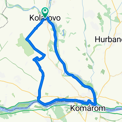
 Kolárovo - Komarno - Zlatná - Kameničná - Kolárovo
- Distance
- 62.5 km
- Ascent
- 88 m
- Descent
- 89 m
- Location
- Kolárovo, Nitra Region, Slovakia
 MTB45 2026
- Distance
- 43.4 km
- Ascent
- 56 m
- Descent
- 57 m
- Location
- Kolárovo, Nitra Region, Slovakia
 Tip Top Túra 25/45
- Distance
- 23 km
- Ascent
- 13 m
- Descent
- 12 m
- Location
- Kolárovo, Nitra Region, Slovakia
 Kolárovo Cycling
- Distance
- 64 km
- Ascent
- 29 m
- Descent
- 33 m
- Location
- Kolárovo, Nitra Region, Slovakia
Open it in the app