

Santa Clara Baja
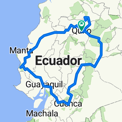
A cycling route starting in Quito, Pichincha, Ecuador.
Overview
About this route
Santa Clara Baja
- -:--
- Duration
- 24.4 km
- Distance
- 484 m
- Ascent
- 581 m
- Descent
- ---
- Avg. speed
- ---
- Max. altitude

Route highlights
Points of interest along the route
Point of interest after 24.4 km
Parqueadero
Continue with Bikemap
Use, edit, or download this cycling route
You would like to ride Santa Clara Baja or customize it for your own trip? Here is what you can do with this Bikemap route:
Free features
- Save this route as favorite or in collections
- Copy & plan your own version of this route
- Sync your route with Garmin or Wahoo
Premium features
Free trial for 3 days, or one-time payment. More about Bikemap Premium.
- Navigate this route on iOS & Android
- Export a GPX / KML file of this route
- Create your custom printout (try it for free)
- Download this route for offline navigation
Discover more Premium features.
Get Bikemap PremiumFrom our community
Other popular routes starting in Quito
 De QF4H+XVR, Quito a QF4H+XVR, Quito
- Distance
- 31.3 km
- Ascent
- 491 m
- Descent
- 505 m
- Location
- Quito, Pichincha, Ecuador
 De Avenida Rodrigo de Chávez 1399, Quito a Gonzalo Díaz de Pineda 186, Quito
- Distance
- 25.5 km
- Ascent
- 381 m
- Descent
- 406 m
- Location
- Quito, Pichincha, Ecuador
 CHIRIVUELTA
- Distance
- 66.3 km
- Ascent
- 1,088 m
- Descent
- 3,253 m
- Location
- Quito, Pichincha, Ecuador
 Zeppelin_EXPLORE_Ecuador_2015
- Distance
- 1,696.3 km
- Ascent
- 10,606 m
- Descent
- 10,586 m
- Location
- Quito, Pichincha, Ecuador
 Santa Clara Baja
- Distance
- 24.4 km
- Ascent
- 484 m
- Descent
- 581 m
- Location
- Quito, Pichincha, Ecuador
 Ruta Jesus de Nazareth ( Giron - Transito - Santa Rosa I - Parque de Cillogallo)
- Distance
- 3.3 km
- Ascent
- 4 m
- Descent
- 66 m
- Location
- Quito, Pichincha, Ecuador
 la cuyada de minas
- Distance
- 78.4 km
- Ascent
- 1,256 m
- Descent
- 1,666 m
- Location
- Quito, Pichincha, Ecuador
 CHIRIVUELTA
- Distance
- 66.2 km
- Ascent
- 1,272 m
- Descent
- 3,396 m
- Location
- Quito, Pichincha, Ecuador
Open it in the app