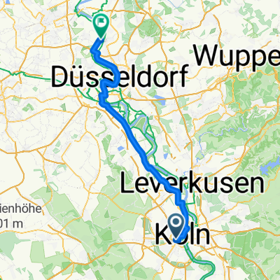
Zievernischer Mühle - Bergheim
A cycling route starting in Cologne, North Rhine-Westphalia, Germany.
Overview
About this route
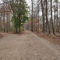
Away from noise and hustle, nestled in an idyllic forest location right on the Erft River, lies the Zievernischer Mühle on the outskirts of Bergheim. A perfect location for day trips to numerous sights in the beautiful Erft floodplain landscape.
- -:--
- Duration
- 55.9 km
- Distance
- 187 m
- Ascent
- 190 m
- Descent
- ---
- Avg. speed
- ---
- Max. altitude
Route quality
Waytypes & surfaces along the route
Waytypes
Path
25.1 km
(45 %)
Track
11.7 km
(21 %)
Surfaces
Paved
38 km
(68 %)
Unpaved
9.5 km
(17 %)
Asphalt
37.4 km
(67 %)
Gravel
6.1 km
(11 %)
Route highlights
Points of interest along the route
Accommodation after 26.8 km
Zievericher Mühle Angelpark Zievericher Mühle 6, 50126 Bergheim Öffnungszeiten: 09:00–23:00 Telefon: 02271 43143
Continue with Bikemap
Use, edit, or download this cycling route
You would like to ride Zievernischer Mühle - Bergheim or customize it for your own trip? Here is what you can do with this Bikemap route:
Free features
- Save this route as favorite or in collections
- Copy & plan your own version of this route
- Sync your route with Garmin or Wahoo
Premium features
Free trial for 3 days, or one-time payment. More about Bikemap Premium.
- Navigate this route on iOS & Android
- Export a GPX / KML file of this route
- Create your custom printout (try it for free)
- Download this route for offline navigation
Discover more Premium features.
Get Bikemap PremiumFrom our community
Other popular routes starting in Cologne
- Feierabendrunde durchs Bergische
- Distance
- 66 km
- Ascent
- 385 m
- Descent
- 387 m
- Location
- Cologne, North Rhine-Westphalia, Germany
- Kleine nach Feierabendstrecke
- Distance
- 16.4 km
- Ascent
- 60 m
- Descent
- 63 m
- Location
- Cologne, North Rhine-Westphalia, Germany
- Petersberg
- Distance
- 127.8 km
- Ascent
- 717 m
- Descent
- 720 m
- Location
- Cologne, North Rhine-Westphalia, Germany
- Kurze Runde
- Distance
- 29.5 km
- Ascent
- 107 m
- Descent
- 107 m
- Location
- Cologne, North Rhine-Westphalia, Germany
- Kölner-Rheintour
- Distance
- 28.9 km
- Ascent
- 118 m
- Descent
- 121 m
- Location
- Cologne, North Rhine-Westphalia, Germany
- Route in Köln
- Distance
- 34.2 km
- Ascent
- 66 m
- Descent
- 67 m
- Location
- Cologne, North Rhine-Westphalia, Germany
- Stadtführung Köln, Spaziergang oder Radtour Süd von www.stadtspiele - verlag.de
- Distance
- 14.8 km
- Ascent
- 56 m
- Descent
- 52 m
- Location
- Cologne, North Rhine-Westphalia, Germany
- anna
- Distance
- 32.7 km
- Ascent
- 73 m
- Descent
- 79 m
- Location
- Cologne, North Rhine-Westphalia, Germany
Open it in the app