

Alpencross 2010 | Etappe 3
A cycling route starting in Scuol, Grisons, Switzerland.
Overview
About this route
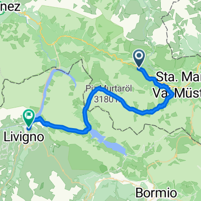
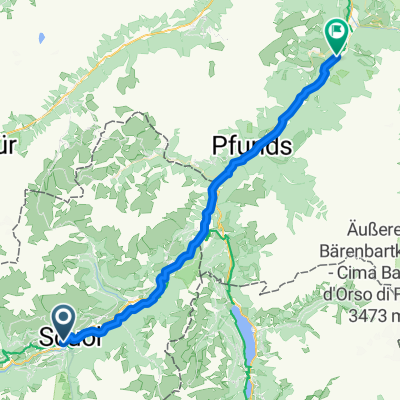
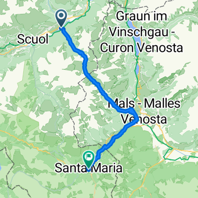
Ramosch – Sur En – Val d'Uina – Schleis – Laatsch – Müstair – Santa Maria – Val Mora – Lago San Giacomo – Lago di Cancano
From Sur En along the stream, a steep gravel road leads to Uina Dadaint. Here you don’t yet realize what awaits you. Shortly after Uina Dadaint, the riding ends and I also have no desire to ride here – one false step would be enough to no longer be among the living. Val di Uina is a highlight for every biker on a Transalp route. Then it continues to the Sesvenna hut – partially rideable. From Sesvenna, a very steep gravel road leads to Schling (and further on asphalt to Prad). Now it goes along the Stelvio pass road to the Sulden junction and further to Sulden. From Sulden, it goes on a very steep gravel road to the Schaubach hut.
- -:--
- Duration
- 73.7 km
- Distance
- 2,522 m
- Ascent
- 1,811 m
- Descent
- ---
- Avg. speed
- ---
- Max. altitude

Route highlights
Points of interest along the route

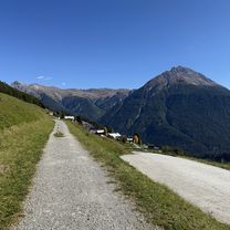
Photo after 11.6 km
Val d'Uina

Photo after 48.3 km
Döss Radond

Photo after 57.2 km
Val Mora

Photo after 68 km
Lago di San Giacomo
Continue with Bikemap
Use, edit, or download this cycling route
You would like to ride Alpencross 2010 | Etappe 3 or customize it for your own trip? Here is what you can do with this Bikemap route:
Free features
- Save this route as favorite or in collections
- Copy & plan your own version of this route
- Sync your route with Garmin or Wahoo
Premium features
Free trial for 3 days, or one-time payment. More about Bikemap Premium.
- Navigate this route on iOS & Android
- Export a GPX / KML file of this route
- Create your custom printout (try it for free)
- Download this route for offline navigation
Discover more Premium features.
Get Bikemap PremiumFrom our community
Other popular routes starting in Scuol
 Brentschpark C, Scuol nach Stradun 327, Scuol
- Distance
- 35.8 km
- Ascent
- 1,029 m
- Descent
- 1,027 m
- Location
- Scuol, Grisons, Switzerland
 444-01: Nationalpark Bike-Tour. Etappe 1 Scuol - Tschierv
- Distance
- 30.9 km
- Ascent
- 1,360 m
- Descent
- 979 m
- Location
- Scuol, Grisons, Switzerland
 444-02: Nationalpark Bike-Tour. Etappe 2 Tschierv - Livigno
- Distance
- 39.6 km
- Ascent
- 1,467 m
- Descent
- 1,324 m
- Location
- Scuol, Grisons, Switzerland
 Scuol nach Ried im Oberinntal (Innradweg)
- Distance
- 46.9 km
- Ascent
- 1,107 m
- Descent
- 1,492 m
- Location
- Scuol, Grisons, Switzerland
 Uina Schlucht (Engadin)
- Distance
- 84.5 km
- Ascent
- 2,509 m
- Descent
- 2,509 m
- Location
- Scuol, Grisons, Switzerland
 Nationalpark Bike-Marathon - Start in S'charl
- Distance
- 132.9 km
- Ascent
- 3,165 m
- Descent
- 3,165 m
- Location
- Scuol, Grisons, Switzerland
 Transalp Etappe 4: Sur En - Santa Maria
- Distance
- 39.4 km
- Ascent
- 1,728 m
- Descent
- 1,483 m
- Location
- Scuol, Grisons, Switzerland
 Jakobsweg Graubünden, Scuol nach Vichava, Ftan
- Distance
- 40.8 km
- Ascent
- 1,495 m
- Descent
- 1,318 m
- Location
- Scuol, Grisons, Switzerland
Open it in the app