

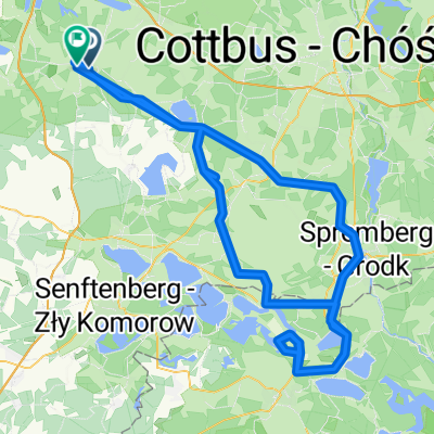
RTF 120 km Rund um die Calauer Schweiz 2017
A cycling route starting in Kalawa, Brandenburg, Germany.
Overview
About this route
This is the 120 km route of the RTF 'Around the Calauer Schweiz' from the year 2017.
- -:--
- Duration
- 115.3 km
- Distance
- 348 m
- Ascent
- 349 m
- Descent
- ---
- Avg. speed
- ---
- Max. altitude
Route quality
Waytypes & surfaces along the route
Waytypes
Road
34.6 km
(30 %)
Track
24.2 km
(21 %)
Surfaces
Paved
108.4 km
(94 %)
Asphalt
104.9 km
(91 %)
Concrete
2.3 km
(2 %)
Continue with Bikemap
Use, edit, or download this cycling route
You would like to ride RTF 120 km Rund um die Calauer Schweiz 2017 or customize it for your own trip? Here is what you can do with this Bikemap route:
Free features
- Save this route as favorite or in collections
- Copy & plan your own version of this route
- Split it into stages to create a multi-day tour
- Sync your route with Garmin or Wahoo
Premium features
Free trial for 3 days, or one-time payment. More about Bikemap Premium.
- Navigate this route on iOS & Android
- Export a GPX / KML file of this route
- Create your custom printout (try it for free)
- Download this route for offline navigation
Discover more Premium features.
Get Bikemap PremiumFrom our community
Other popular routes starting in Kalawa
 RTF Calauer Schweiz 2012
- Distance
- 142.2 km
- Ascent
- 408 m
- Descent
- 408 m
- Location
- Kalawa, Brandenburg, Germany
 Altdöberner Tagebausee
- Distance
- 51.1 km
- Ascent
- 176 m
- Descent
- 178 m
- Location
- Kalawa, Brandenburg, Germany
 Single Tour 1.5.2020
- Distance
- 59 km
- Ascent
- 186 m
- Descent
- 186 m
- Location
- Kalawa, Brandenburg, Germany
 RTF - Calau (ungefähr ;) )
- Distance
- 78.4 km
- Ascent
- 289 m
- Descent
- 291 m
- Location
- Kalawa, Brandenburg, Germany
 Runde zur 'Ranch' bei Hoyerswerda
- Distance
- 162.3 km
- Ascent
- 283 m
- Descent
- 270 m
- Location
- Kalawa, Brandenburg, Germany
 Schlabendorf inline
- Distance
- 47.2 km
- Ascent
- 42 m
- Descent
- 42 m
- Location
- Kalawa, Brandenburg, Germany
 Säritz, Ortsmitte, Calau nach Neue Gartenstraße 4, Luckau
- Distance
- 10.2 km
- Ascent
- 70 m
- Descent
- 87 m
- Location
- Kalawa, Brandenburg, Germany
 Calau-Burg-Calau 50,5 km
- Distance
- 52.5 km
- Ascent
- 87 m
- Descent
- 90 m
- Location
- Kalawa, Brandenburg, Germany
Open it in the app